How Geolocation Metadata Enriches Cross-Border Memorial Tapestries
The Missing Geographic Layer in Most Memorial Platforms
A daughter in Vancouver scrolled through 89 stories her family had contributed about her father. She knew her father had worked in five countries. She could not, reading story by story, reconstruct the sequence. The platform had preserved the words but lost the places. She closed the browser tab and wept. This is the limitation of most memorial platforms: they capture what happened but not where.
Wikipedia's entry on geotagging describes the standard practice of attaching coordinates, bearing, and timestamps to media — mature technology in photography and mapping, but largely absent from memorial tools. Springer research on extracting knowledge from geo-tagged media demonstrates the analytical value of this metadata at scale. eCampusOntario's spatial humanities curriculum argues that place-based narratives are a distinct genre demanding distinct tools, not just a presentation filter on text.
Real-world examples show what is possible. Esri's work on documenting oral history through maps shows how oral histories gain meaning when anchored to place. Monument Lab's national monument audit maps commemorative places at scale. Services like Etern.life use geotagging to mark final resting places, and ArcGIS StoryMaps layers narrative onto interactive maps for any subject. The memorial industry has lagged behind these peer domains.
Weaving Geography Into the Tapestry
The tapestry metaphor extends to geography: each story thread has a point of origin, and the tapestry as a whole reveals a geographic weave invisible to text-only memorials. StoryTapestry treats geolocation not as an optional decoration but as a first-class metadata dimension that every contribution carries.
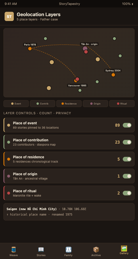
Five geolocation layers work together in a diaspora memorial:
Place of event: Where did the story happen? Each contribution prompts: where did this take place? A cousin's story about a 1982 beach trip gets pinned to the Mediterranean coast of Lebanon. A colleague's story about a 1999 conference gets pinned to São Paulo. This is the primary geographic layer and the one most families populate richly once prompted.
Place of contribution: Where is the contributor now? Every contributor's current location is captured at the point of submission. This creates the diaspora map — a literal visualization of where the grieving community has scattered. Patterns emerge: a cluster in Queens, a cluster in Toronto, an outlier in Lagos. Families see their own geography reflected back.
Place of residence: Where did the decedent live? A chronological track of residences across the decedent's life, each pinned with dates. This layer alone can reveal patterns the family had forgotten — a forgotten six-month stint in a sister city during a work assignment, a summer home that defined childhood.
Place of origin: Where is the family from? The ancestral place layer, often going deeper than living memory. For multinational tapestry weaving, this layer anchors the tapestry to a shared origin — a village, a watershed, a historical region — that distant cousins can still recognize.
Place of ritual: Where did commemoration happen? Funeral rite locations, memorial gatherings, scattering of ashes, planting of memorial trees. For families who hold rites in multiple countries, this layer documents the geographic footprint of mourning itself — similar to the overseas story logistics that consular-supported families navigate.
When the daughter in Vancouver opened the same memorial with geolocation enabled, she saw her father's life as a map of intersecting tracks — his residence path, his contributors' current locations, and the places of each story — overlaid on a single interactive view. She finally saw the pattern the text had hidden. This kind of geographic reconstruction parallels geospatial deployment mapping work in the veteran memorial space, where mapping a service member's deployments anchors the stories told about them.
The geolocation layer also addresses a particular grief experience common in diaspora families: the reconstruction of geography from second and third-generation memory. A grandchild who has never visited the ancestral village can, through the memorial map, see exactly where the family's story began, where migration took them, and how each branch scattered across the world. For children of migrants who often carry a vague sense of ancestral origin without specific detail, the map transforms abstract heritage into concrete geography. A Vietnamese-American teenager learning for the first time that her grandmother grew up specifically in Tân An rather than vaguely "in Vietnam" often describes the experience as suddenly having a place to claim. StoryTapestry's geolocation enrichment is as much about connecting descendants to origin as about documenting events.
Advanced Tactics for Geolocation Enrichment
Geolocation metadata is only as useful as its precision and its respect for privacy. Four tactics sharpen implementation:
Prompt for place, then confirm coordinates. Do not ask contributors for GPS coordinates. Ask: "Where did this take place?" Accept freeform text (a city, a neighborhood, a landmark). The platform geocodes the answer and presents a map pin for confirmation. Contributors correct the pin if needed. This two-step flow gets 3-4x more geolocation coverage than direct coordinate prompts.
Default to neighborhood precision, not street address. Pinning a story to "Brooklyn, NY" is more useful than pinning to a specific address — it protects privacy and accommodates the vagueness of memory. Streets change names; neighborhoods persist. Offer street-level precision only when contributors explicitly request it.
Offer historical place names. A grandmother born in Saigon lived there before the 1975 renaming. Her birth story pin should read "Saigon (now Ho Chi Minh City)" with coordinates at the historical city center. This respects the language the contributor uses and preserves history. Build a historical place name registry for the top 500 diaspora source cities.
Surface the geographic distribution in the family review. Before publication, show the family coordinator a map view of the tapestry. Gaps — a decade where no stories have a location — prompt targeted outreach. A missing geography is often a missing contributor; the map makes this visible.
Tag stories with multiple places when appropriate. A story about a phone call between Beirut and Porto Alegre gets two pins. A story about a migration gets a line from origin to destination. The map supports multi-pin and path-style annotations natively.
Respect geographic sensitivity. Some diaspora communities have reasons to obscure birthplace or residence details. Offer a "region only" privacy setting per story. A refugee family may want a story pinned only to "Southern Lebanon" rather than to the specific village. The platform honors the setting throughout the tapestry.
Handle border changes and disputed territories carefully. A grandparent born in what is now Ukraine may have been born when the region was part of Poland, Austria-Hungary, or the Soviet Union depending on the era. A family in present-day Israel may have roots in an area now contested. StoryTapestry's historical place registry handles these situations by documenting the place under its contemporaneous name, its current name, and any politically sensitive framing the family prefers. Staff do not have to adjudicate which name is correct; the platform simply presents the family's chosen framing with appropriate historical context.
Link geography to family reunion planning for years after the service. The memorial map often becomes the blueprint for a family reunion two or three years after the death. A Greek-American family that reconstructed their grandmother's path from Chios to Astoria, Queens often decides to organize a multi-generational trip to Chios a year or two later. StoryTapestry's reunion planning tools connect the memorial map to concrete travel coordination, so the geographic awareness the memorial created becomes a continuing family experience rather than a one-time artifact.
Support temporal-geographic layers for lives shaped by migration timing. A refugee's journey from their home country through transit countries to final resettlement carries temporal meaning as important as the geography itself. A Sudanese family may trace their elder's path from Khartoum through Cairo to Dallas across specific years and months, each stop representing a different chapter of survival and adaptation. The map can animate these transitions chronologically, showing viewers not just where the person went but when and under what circumstances. For families whose stories were shaped by flight, war, or persecution, this temporal-geographic layer becomes a form of historical documentation that serves grieving descendants and future researchers alike.
Take the Next Step
StoryTapestry treats place as a first-class memorial dimension because diaspora lives are geographic lives. If your platform displays stories as a list with no map view, you are missing half the story. We will run a geolocation-enrichment pass on a redacted sample memorial you provide and return a map view alongside the existing narrative. See your tapestry from above for the first time — then judge whether this layer belongs in your standard offering. Contact our product team to start. The enrichment pass includes place-of-event pinning for each story, place-of-contribution capture for each contributor, place-of-residence chronology for the deceased, place-of-origin anchoring, and place-of-ritual documentation for any memorial gatherings. We return a fully rendered map view with your redacted sample data along with an assessment of which enrichment layers would add the most value for your typical caseload.
Funeral homes serving highly mobile diaspora populations often discover that geolocation becomes a signature feature families remember and discuss with their communities, because the map view makes the geographic sweep of a diaspora life visible in a way no text archive can. The map is often what grandchildren return to years after the service, tracing the path their family took across the world as they develop their own sense of where they come from. Your families' lives are too geographic to flatten into a list; the map gives their memorials the dimensional fidelity they deserve.