How Geospatial Deployment Mapping Enhances Veteran Life Tapestries
The Lost Geography of Veteran Lives
Commander Elena Reyes retired in 2018 after 24 years in the Navy. Her assignments moved her family 11 times: Officer Candidate School in Pensacola, first surface-warfare tour in San Diego, a Japan tour in Yokosuka, Bahrain during the 2003 Iraq campaign, command tour at Norfolk, and onward through staff tours in Keflavik, Naples, and finally Washington DC. When she died in 2025, her memorial obituary mentioned Pensacola (where she commissioned), Norfolk (where she commanded), and DC (where she retired). The other eight stations vanished.
Military life is inherently geographic. Pew Research analysis of America's veterans documents 18 million living veterans distributed across all 50 states with service histories spanning hundreds of installations worldwide. Data.gov's military bases dataset catalogs the authoritative DoD installation list that supports any serious geospatial memorial work. The National Archives military service records remain the primary source for deployment dates and locations when family records are incomplete.
Despite the abundance of geographic source data, funeral home memorial software treats location as a single field: hometown. Veteran memorials lose the 11-station reality that defined the actual lived experience. Comrade contributors from San Diego and Bahrain have no visual thread tying their memories to the memorial, because the memorial never acknowledges they were part of the geography.
UNC's Healthy Vets GIS mapping work and the Army's GIS mapping of Soldier health demonstrate academic and operational precedents for veteran geospatial analysis in other domains. Memorial programs have lagged behind these adjacent fields in adopting geospatial structure for memorial contexts. DTS Map is one consumer tool mapping veteran deployment histories, validating demand for geospatial memorial features even from individual veterans not yet deceased.
Geospatial Weaving in StoryTapestry
StoryTapestry's deployment mapping turns each assignment into a geographic chapter with a pin on an interactive world map. Commander Reyes's 11 stations become 11 chapter pins. Comrade contributions bind to their respective pins. Photos upload with geolocation tags when available. The map itself becomes a tapestry—threads of service drawn across the globe, each station colored by the duration and weight of the chapter.
Data ingestion from service records. The coordinator uploads the veteran's DD-214 or assignment history, and StoryTapestry extracts station dates, unit assignments, and deployment locations. For stations not on the DD-214 (detached duty, TDYs, joint assignments), the coordinator can manually add chapters. The system references the authoritative installation dataset to ensure stations resolve to correct geographic coordinates. The Army Geospatial Center maintains the underlying data standards.
Pin typology. Not all geographic chapters carry equal weight. StoryTapestry distinguishes four pin types: home station (duty assignment of 12+ months), deployment (operational tour in a combat zone or forward area), detached duty (TDY, exercises, schools under 12 months), and personal (places of personal significance tied to service, like a first liberty port or a PCS route the family traveled). Each pin type uses distinct visual treatment so viewers immediately parse the chapter typology. This layered approach parallels career comrade case study reconstruction techniques where chapter weighting matters.
Timeline-to-map coupling. The map integrates with the memorial's timeline slider. Dragging the timeline to 2003-2004 illuminates the Bahrain pin while fading the other stations. Viewers can watch the deployment sequence unfold chronologically, which is especially powerful for long-career memorials. This temporal-geographic coupling is the same pattern that makes modern AI comrade matching viable—when the system knows who was where when, it can surface contributor overlaps.
Comrade geo-routing. When a comrade receives an invitation to contribute, the invitation references the specific station they overlapped with the veteran. A Yokosuka peer from 2001 receives a prompt anchored to the Japan chapter. A Bahrain deployment buddy from 2003 receives a prompt anchored to that specific deployment. Geo-specific prompting produces 40%+ higher contribution rates than generic "share a memory" invitations, per StoryTapestry deployment data.
Station-level engagement views. Families can click any pin to see the station's full chapter: dates, unit assignments, comrade contributions, photos, and stories specific to that geography. The San Diego chapter becomes its own sub-tapestry within the overall career tapestry. This aligns with audio waveform technology patterns in adjacent memorial domains where sensory/temporal binding creates meaningful memorial layers.
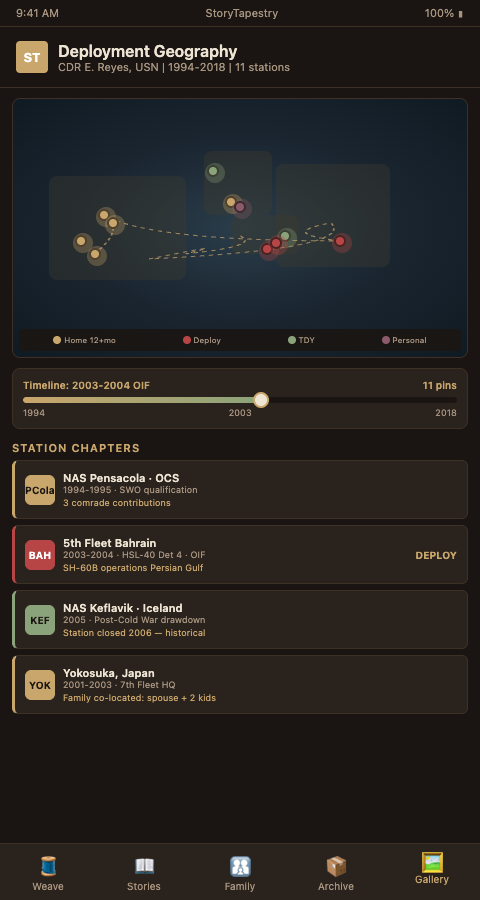
Historical station context. For stations that closed (Naval Station Keflavik closed in 2006) or changed mission substantially, the memorial displays historical context. Viewers see that the installation no longer exists but that the veteran served there during its operational era. This context matters because family members and younger contributors often cannot locate decommissioned stations without it.
Installation-era mission context. Beyond closure status, each station carried a specific operational mission during the veteran's tour that the memorial captures. Keflavik during Commander Reyes's staff tour in the early 2000s was part of the post-Cold-War Iceland Defense Force wind-down; Keflavik during a 1985 tour would have been at the height of Cold War maritime patrol operations against Soviet submarines. The same station name carries different meaning across eras, and the memorial renders the station-era mission accurately so the chapter reflects what the veteran actually did there rather than a generic installation reference. This specificity matters particularly for Cold War-era veterans whose stations served strategic purposes that no longer exist but whose operational reality defined their daily work during service.
Advanced Geospatial Memorial Tactics
Route visualization between stations adds PCS (Permanent Change of Station) narrative depth. Military families often have distinct memories of the cross-country drives, international moves, and family separations that connected assignments. A line drawn from Pensacola to San Diego to Yokosuka with animation along the route invites family contributions about the move itself: the U-Haul breakdowns, the kids' first flight overseas, the port-of-call visits.
Overlaying unit deployment histories on the map connects the veteran's personal path to unit-level context. When Commander Reyes deployed to Bahrain in 2003, she did so with a specific squadron whose deployment history, aircraft types, and operational tempo are documented in public-domain sources. StoryTapestry overlays this unit context on the pin so viewers see not just "Bahrain, 2003" but "Bahrain 2003 with HSL-40 Detachment 4 flying SH-60B operations in support of OIF."
Family co-location mapping shows where the family lived while the service member served. Separation was a defining feature of many military careers, and geographic mapping that shows Mom-and-kids-in-Virginia while Dad-was-in-Afghanistan honors the family's parallel experience. This dual-track geography deepens the memorial's authenticity for the spouse and children who often carry as much service memory as the veteran themselves.
Cultural context layers add interpretive depth. For overseas stations, the map can reference local cultural notes: the Yokosuka chapter might include references to the surrounding naval base community, Japanese host-nation relationships, and the specific liberty port culture of that era. Context grounds the geographic chapter in a lived experience rather than a bureaucratic location code.
Multi-veteran memorial comparisons surface patterns across a funeral home's veteran caseload. Aggregated maps (de-identified) showing where the Norfolk funeral home's veterans served reveal clustering: a high concentration around Norfolk, Virginia Beach, and east-coast Navy installations, reflecting the local demographic. This data supports outreach planning to unit reunion networks and local VSO partnerships.
Ship-based service patterns deserve dedicated treatment on the map. A Navy sailor's career includes underway periods where the ship operated in specific geographic areas during specific deployments. Commander Reyes's Bahrain-era deployment involved operations across the Persian Gulf, the Strait of Hormuz, and potentially the Red Sea depending on her squadron's mission set. The tapestry can render these operational areas as shaded polygons on the map rather than single-point pins, showing the geographic reach of shipboard service more accurately than a single Bahrain pin could convey. The same approach works for carrier strike group deployments, submarine patrol areas, and Coast Guard cutter operations where the geographic reach of service far exceeds any single port.
Overseas liberty port history adds personal texture. Navy and Marine veterans often remember specific liberty ports with deep affection or vivid stories, and the memorial can capture these places as personal-significance pins alongside the operational pins. A sailor who took liberty in Cinque Terre during a Mediterranean deployment in 1992 may have family photographs from that specific visit that belong on the map alongside the deployment track that brought the ship through the region.
Domestic family co-location shows the parallel geography of military spouse experience. While a service member served in Yokosuka, the family may have lived in Navy Gateway Inns and Suites while waiting for base housing, or in off-base Japanese neighborhoods that the spouse's memoir can describe in detail. The dual-track geographic mapping honors this parallel experience rather than treating the map as purely a service-member track.
Map Your Next Veteran Memorial
Veteran Memorial Programs ignoring geographic structure are losing one of the richest narrative dimensions available. StoryTapestry's deployment mapping turns installation data into interactive tapestry chapters, with comrade routing, timeline coupling, and historical station context built in. Request a deployment-map walkthrough with a StoryTapestry specialist using a sample DD-214 to see how 11 stations render as one continuous geographic tapestry. Commander Reyes's memorial deserves all 11 stations, not just the three her obituary mentioned.
The walkthrough covers geographic mapping across representative service profiles: a Vietnam-era Army infantryman with multiple areas of operation across III Corps Tactical Zone in Vietnam, a Cold War Air Force fighter pilot with assignments across European NATO bases, and a post-9/11 Navy SEAL whose operational geography spans classified deployment locations that the memorial handles with appropriate abstraction. Each profile exercises different parts of the mapping infrastructure and demonstrates how the platform handles everything from precise base coordinates to classified operational areas that cannot be pinned publicly. Firms near major military installations with long deployment histories—Norfolk, San Diego, Jacksonville, Pensacola, Pearl Harbor, Joint Base Andrews, and countless others—typically see the richest value from geospatial memorial work because their caseload includes veterans with complex global service patterns.
Firms serving inland communities benefit equally because Army and Air Force veterans from inland bases also served across global assignments that the flat obituary tradition cannot capture. Schedule the walkthrough with a DD-214 from your pending intake queue, whether the veteran served eight years as a Marine with one Okinawa tour or twenty-eight years as a Navy officer with stations across four continents. Every station earned its place on the map, and the tapestry will render each one with the weight the family deserves to see.