5 Critical Safety Zones Every Urban Implosion Plan Needs
Why "Half the Building Height" Is Not a Safety Zone
The NFDC Demolition Exclusion Zones guidance DRG110:2021 makes the point precisely: exclusion zone size must be assessed based on debris projection energy, not building height. A 20-story reinforced concrete building with post-tensioned slabs generates significantly more lateral fragment energy than a 30-story steel-frame tower with lightweight curtain wall cladding. Using height as a proxy produces exclusion zones that are either dangerously undersized for concrete towers or operationally excessive for steel-frame buildings.
This distinction has legal weight. OSHA demolition standards under Subpart T and U require structural surveys and blaster-certified exclusion zone planning — not height-based rules of thumb. When a neighboring structure sustains damage during an implosion, the first document investigators request is the exclusion zone calculation methodology. "Standard industry practice" based on height multipliers is not a defensible methodology when peer-reviewed guidance establishes physics-based calculation as the standard.
The US demolition and wrecking industry reached $11.2B in 2025, with urban high-rise implosion as one of the most specialized and highest-value segments. The liability exposure in that market segment scales with building height, urban density, and proximity to occupied structures — all of which make rigorous safety zone calculation a financial priority, not just a regulatory one.
Urban demolition safety requirements across major US and UK jurisdictions have converged on one standard: the building demolition safety perimeter must be derived from a site-specific engineering calculation, not a fixed multiple of building height. Setting up the high-rise blast safety radius before a single charge is specified — and updating it as the charge map evolves — is the discipline that separates projects with clean permit applications from those with last-minute zone revisions. Implosion exclusion zone planning that begins alongside charge design rather than after it catches conflicts before they require workplan amendments.
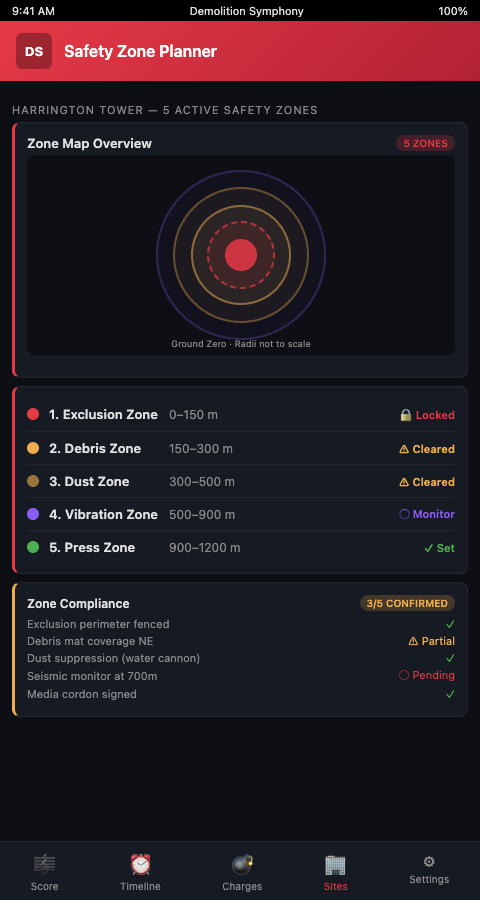
Five Zones, Five Calculations
A complete urban implosion safety plan requires five distinct urban implosion safety zones, each with its own boundary calculation and occupancy rule. The Demolition Symphony Planner maps these zones as overlapping rings in the planning interface, each linked to the charge placement and delay data that determines its boundary.
Zone 1: The Inner Exclusion Zone. The hard boundary within which no personnel or equipment may be present during detonation. Its radius is calculated from the debris projection energy of the lowest-floor charges — which generate the highest lateral fragment velocity before the progressive collapse redirects energy downward. The Association of Pyrotechnics guidance defines the methodology: calculate the predicted debris boundary from fragment ballistics, then add the buffer distance between predicted boundary and formal exclusion perimeter. That buffer accounts for uncertainty in the structural condition assessment and detonator timing tolerances.
Zone 2: The Dust and Overpressure Zone. Immediately outside the inner exclusion zone, this area is exposed to the dust cloud generated by the collapse and the overpressure wave from the detonation sequence. Personnel in this zone must wear respiratory protection and remain behind a physical barrier. The dust cloud radius for a reinforced concrete tower in urban conditions typically extends 1.5 to 2.5 times the inner exclusion zone radius, depending on wind conditions at blast time. This zone boundary must be recalculated if wind forecasts change within 48 hours of the scheduled implosion.
Zone 3: The Vibration Monitoring Zone. The Kochi implosion study required a 200-meter evacuation radius and real-time vibration monitoring at multiple radial distances. Within the vibration monitoring zone, all sensitive structures — hospitals, historic buildings, structures with known foundation vulnerabilities — require instrumented monitoring during detonation. The zone boundary is determined by propagating the predicted peak particle velocity from the detonation network outward until it falls below the damage threshold for the most sensitive adjacent structure.
Zone 4: The Public Exclusion Zone. This is the boundary within which public movement must be stopped during the blast window. In dense urban environments, this zone must account for transit routes, pedestrian corridors, and vehicle access roads. New York City's Building Code Section S3306.2.2 codifies minimum safety zone distances for exterior demolition in dense urban contexts — a useful regulatory floor, but one that should be supplemented by site-specific debris energy calculations for implosion events.
Zone 5: The Airspace and Emergency Access Zone. Drone and helicopter operations must be restricted during the blast window and the immediate post-blast dust-cloud period. Emergency vehicle access routes must be pre-planned within this zone, cleared before detonation, and verified clear before the first charge fires.
The five-zone framework is most useful when all five zones are represented in the same planning document as the charge placement map and the delay sequence. When the Demolition Symphony Planner maps these zones as overlapping rings tied to the charge placement layer, a change in any charge specification automatically flags the affected zone boundaries for recalculation. A coordinator who adds a second charge to a column on floor 3 — because the field survey revealed thicker concrete than the original drawings showed — sees immediately which zone boundaries that change affects, and can recalculate before the permit is filed rather than after the blast.
This linkage between the charge placement score and the zone boundaries changes the safety planning workflow from a sequential process (finish charge map, then calculate zones) to a parallel process (develop charge map and zones together). The parallel approach catches charge-zone inconsistencies during design rather than during permit review or — worse — during the blast itself.
The asymmetry of urban implosion sites also matters for zone calculation. A rectangular zone centered on the building footprint fails to account for the fact that wind conditions, neighboring structure proximity, and collapse direction are all asymmetric. Each zone should be calculated as a non-circular boundary derived from the actual blast physics and site geometry — not as a uniform radius that's conservative in one direction and potentially undersized in another.
For the charge placement and debris footprint data that feeds Zone 1 and Zone 2 boundary calculations, the debris footprint prediction post covers the simulation methods used to model where debris lands under different sequence configurations.
Advanced Safety Zone Considerations
Dynamic zone adjustment. Safety zone boundaries calculated from the original blast plan must be updated whenever the charge configuration changes. If the structural assessment reveals additional post-tensioned slabs on floors 12-18 that require additional charges, the inner exclusion zone boundary changes. In the Demolition Symphony Planner, safety zones are linked to the charge placement layer — any charge modification triggers a recalculation flag on the zone boundary.
Cross-structure vibration thresholds. Adjacent structures in dense urban environments have different vibration damage thresholds. A 1920s masonry building 80 meters from the blast perimeter has a different threshold than a 1990s reinforced concrete tower at the same distance. The vibration monitoring zone boundary must be calculated for the most sensitive adjacent structure in each radial direction, not as a uniform circle.
Coordination with bridge and infrastructure demolition sites. Teams transitioning from bridge demolition to high-rise implosion work frequently underestimate the safety zone complexity at urban implosion sites. The adjacent infrastructure risks post covers the infrastructure interdependency assessment that must inform Zone 3 boundary calculations when utilities, transit corridors, or active construction sites sit within the vibration monitoring radius.
Pre-blast assessment as zone input. Safety zone calculations are only as accurate as the structural data feeding them. Under-estimated column charge weights produce under-sized exclusion zones. This is why the pre-blast structural assessment — covered in detail in the pre-blast assessment post — must be completed before any zone boundary is finalized.
Communication as a zone deliverable. Urban implosion projects require notifying neighboring property owners of the safety zones and the blast schedule, often 7-14 days in advance under local ordinances. The five-zone map — produced as a deliverable from the Demolition Symphony Planner's zone planning interface — serves as the primary communication document for this neighbor notification. A clear, professionally formatted zone map reduces the volume of neighbor objections and expedites permit approval because it demonstrates that the implosion team has calculated the impact area rather than relied on a generic radius.
Zone 3 and construction site proximity. Urban implosion sites frequently neighbor active construction projects — new towers going up adjacent to old towers being brought down. An active construction site within the vibration monitoring zone presents a specific challenge: the construction site has its own vibration-sensitive operations (freshly poured concrete, precision equipment, formwork) that have a different damage threshold than a completed building. Zone 3 boundary calculations for sites with adjacent active construction must account for these construction activity thresholds, not just completed structure thresholds. Coordinating with the adjacent construction project manager to schedule the implosion during a period when no freshly poured concrete is within the vibration monitoring zone reduces the risk of construction damage claims alongside any structural damage claims.
Post-blast zone clearance protocol. The zones don't become inactive immediately after the last charge fires. Dust cloud propagation (Zone 2) extends the post-blast exclusion period beyond the detonation window. Vibration monitoring (Zone 3) should continue for 30-60 minutes post-blast to confirm no secondary structural movements are occurring in adjacent buildings. Airspace restriction (Zone 5) typically lifts only after the dust cloud has cleared sufficiently for visual confirmation that no structural debris remains in suspension. The Demolition Symphony Planner includes a post-blast zone clearance protocol as a standard addition to every five-zone safety plan, so the implosion team has a defined sequence for lifting each zone restriction rather than making those calls ad hoc on blast day.
Establish Your Zones Before You Place a Single Charge
Urban high-rise implosion coordinators who establish safety zone boundaries early in the planning process — rather than after the charge placement map is complete — catch structural assessment gaps before they become under-sized exclusion zones. The Demolition Symphony Planner integrates zone boundary calculation directly into the charge placement workflow, so zone boundaries update as the charge map develops rather than being calculated once at the end.
The five-zone framework is only as strong as the input data feeding it. Zone 1 boundaries that are based on assumed rather than measured column charge weights may be undersized by 15-30% — a gap that matters significantly when neighboring structures sit 40 meters from the blast perimeter. Before the permit is filed, each zone boundary should carry a documented source: the structural assessment that produced the charge weights for Zone 1, the dispersion model that produced the dust radius for Zone 2, the vibration survey that established the PPV thresholds for Zone 3. Traceability between the engineering data and the zone boundary is what makes the permit defensible when a neighboring property owner requests documentation.
Join the waitlist for urban high-rise implosion coordinators and get priority access to the five-zone safety planning module when it launches.