Why Debris Footprint Prediction Matters in Dense Cities
The Variable Nobody Talks About
Post-demolished debris scatter is consistently mischaracterized as an unavoidable byproduct of implosion that safety zones simply need to contain. The MDPI debris simulation study on tall building demolition disproves that framing directly: different demolition sequences for the same building produced debris spread from 5.93 m to 39.9 m. The sequence is the primary variable. Safety zones contain the expected footprint — but if the footprint is 39.9 m because the sequence wasn't optimized, no reasonable urban exclusion zone can account for that scatter in a dense city block.
The real-world implication: implosion coordinators who optimize their charge sequence for progressive collapse control are simultaneously optimizing their debris footprint. These aren't separate engineering decisions. A sequence that induces clean directional progressive collapse naturally concentrates debris within a smaller radius, because the kinetic energy is directed downward rather than outward. Debris footprint prediction urban demolition planning starts from this principle: sequence optimization and footprint optimization are the same calculation approached from different angles.
Assessment of Environmental Pollutants of Demolition Sites documents that real-time monitoring at demolition sites shows noise and dust values significantly exceeding permissible limits — and that's during controlled operations that went according to plan. Uncontrolled debris scatter from a poorly sequenced implosion compounds these impacts by distributing particulate matter over a wider area, extending the post-blast environmental assessment period and increasing cleanup costs.
Predicting the Footprint Before Firing
Debris footprint prediction in modern urban implosion planning uses finite element method (FEM) simulation to model how each floor collapses, where the collapse front propagates, and how much lateral energy escapes each floor before the floor above arrives. The Springer modeling study reports 88% accuracy in predicting collapse mechanism and debris distribution using this approach — sufficient for setting exclusion zone boundaries and communicating debris expectations to neighboring property owners.
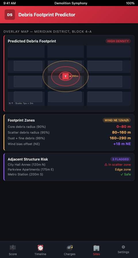
The Demolition Symphony Planner treats the debris footprint simulation as a layer in the visual score, not a separate deliverable. When coordinators adjust the detonation sequence — shifting a delay interval on floor 12, or adding a pre-weakening step at the transfer slab — the debris footprint layer updates to reflect the new sequence's projected scatter. This direct coupling between the sequencing score and the footprint model means coordinators see the footprint consequence of every timing decision in real time, rather than discovering them in a post-blast debrief.
This approach addresses a critical gap in traditional implosion planning: the handoff between the structural engineer who designs the charge sequence and the safety officer who sets the exclusion zones. In most projects, the structural engineer finalizes the sequence, hands it to safety for zone calculation, and any late sequence changes don't automatically update the zone boundaries. With the Demolition Symphony Planner's linked score-and-footprint interface, both the sequence and its debris consequences are always in sync.
The full-scale FEM validation study from ResearchGate validated FEM debris predictions against UAV footage of an actual high-rise implosion, confirming the simulation dispersion patterns matched real-world debris distribution. UAV post-blast surveys are now standard for capturing the evidence base that validates or challenges pre-blast footprint predictions — building a library of validated models for future project calibration.
Debris footprint prediction also has a permitting function beyond exclusion zone sizing. Municipal building departments reviewing demolition permits for dense urban sites increasingly require a debris impact analysis — a document showing where debris is expected to land and confirming it stays within the exclusion zone. The FEM-based debris footprint model in the Demolition Symphony Planner produces this analysis as a formatted output tied to the detonation sequence, so the permit submission document is derived directly from the planning data rather than assembled separately. When the sequence changes during permit review, the debris analysis updates automatically.
The controlled demolition debris radius — the maximum expected distance from the building footprint that any significant debris fragment will travel — is the single number that determines whether a dense urban implosion is viable at a given site. A controlled demolition debris radius of 12 meters is manageable in a city block with 18-meter setbacks. A radius of 35 meters is not. FEM simulation provides this number before the permit is filed, allowing coordinators to determine viability — and optimize the sequence to reduce the radius if necessary — rather than discovering the limitation after contracts are signed.
For the safety zone planning decisions that depend on footprint predictions, safety zone planning covers how to translate debris footprint data into Zone 1 and Zone 2 boundary calculations.
Advanced Footprint Prediction in Dense Urban Contexts
Building replacement frequency. The MDPI Sustainability study on demolition of existing buildings notes that most demolished urban buildings are structurally sound but economically replaced — meaning they have intact load paths and predictable structural behavior. This is actually favorable for footprint prediction: FEM models of structurally sound RC towers perform more accurately than models of damaged or structurally degraded buildings where unknown deterioration alters the collapse mechanism.
High-rise demolition frequency. Buildings & Cities research on demolished building lifetimes shows that high-rise buildings between 10 and 14 stories are demolished after only 13 to 56 years — far shorter than their structural design life. This means debris footprint prediction for mid-rise urban towers is not an occasional specialized task. Urban high-rise implosion coordinators in redevelopment-heavy cities will model debris footprints for buildings of this type repeatedly, and maintaining calibrated FEM models for each building type dramatically speeds up per-project prediction accuracy.
Asymmetric footprints. Not all urban implosions can collapse the building into a symmetric debris pile. When adjacent structures sit closer on one side, the sequence must be designed to bias the collapse away from the sensitive side, which produces an asymmetric debris footprint. Predicting an asymmetric footprint requires modeling the collapse front propagation in three dimensions, not just the vertical collapse progression. The Demolition Symphony Planner's debris footprint layer supports asymmetric sequence configurations and renders the resulting asymmetric scatter pattern as a directional overlay on the site map.
Dust cloud as a separate footprint layer. The debris solid footprint and the dust cloud propagation footprint are different physical phenomena with different boundary distances and environmental impact profiles. The dust cloud modeling post covers the dust propagation calculations specifically — including how wind direction at blast time shifts the dust footprint independently of the solid debris footprint.
Post-blast footprint measurement and model calibration. After the implosion, debris mapping — either by drone survey or ground measurement — provides the empirical footprint for that specific building type, structural condition, and sequence configuration. This measured footprint is the calibration data for the FEM model. Any discrepancy between predicted and measured footprint identifies a model assumption that needs adjustment: structural condition variance, charge weight tolerance, or a collapse mechanism that the model didn't capture. Maintaining a database of calibrated models by building type and structural system is what allows experienced implosion teams to predict debris footprints for similar future projects with progressively higher accuracy.
Sequence optimization as a footprint optimization. The MDPI study's 5.93 m to 39.9 m range wasn't generated by arbitrary sequences — it was generated by systematically varying the detonation order and measuring the footprint consequence of each variation. This is exactly the optimization loop that the Demolition Symphony Planner's score-and-footprint interface supports: adjust the sequence, observe the footprint consequence, and select the sequence configuration that minimizes the debris spread while maintaining the required progressive collapse directionality. For urban high-rise implosion coordinators working on sites with minimal clearance between the building footprint and neighboring structures, this optimization loop is the difference between a viable demolition plan and a permit rejection.
Implosion debris spread modeling and the viability threshold. Before a demolition contract is signed for an urban high-rise, the implosion coordinator should run a preliminary debris footprint model to confirm that the available site clearance is sufficient for the expected controlled demolition debris radius. Running this model during the pre-contract feasibility phase — rather than after the contract is signed — catches infeasible projects before commitment. The Demolition Symphony Planner's preliminary footprint modeling uses building dimensions, structural system type, and approximate sequence parameters to produce a feasibility-grade footprint estimate in under an hour.
For urban neighborhoods facing demolition dust exposure, dust control methods covers the suppression and mitigation techniques that inform the pre-blast environmental impact plan.
Model the Footprint Before You Design the Sequence
Urban high-rise implosion coordinators planning demolitions in dense city blocks — where the difference between 6 meters and 40 meters of debris scatter determines whether the project is viable — need footprint prediction integrated into the sequencing workflow, not appended at the end. The Demolition Symphony Planner gives implosion coordinators a debris footprint simulation layer that updates with every sequence change, so the footprint consequence of each timing decision is visible throughout the planning process.
The urban building demolition debris zone that the FEM model defines before the permit is filed is a defensible, replicable document that the regulator can audit and that the neighboring property owner can review. When that zone is generated from the actual detonation sequence rather than a rule-of-thumb estimate, it is also an accurate document — one that correctly bounds the debris scatter rather than conservatively overstating it in ways that limit site utility. Dense city implosion debris control begins with modeling that produces the real footprint rather than a worst-case approximation, and ends with a suppression design that addresses that specific footprint rather than a generic radius.
Join the waitlist to get early access to the debris footprint simulation module for urban high-rise implosion projects.