How Digital Twins Improve Implosion Accuracy in Dense Urban Areas
How Digital Twins Improve Implosion Accuracy in Dense Urban Areas
A 3D finite element model of a 100-meter high-rise implosion, built from laser scan geometry and validated material properties, produces collapse trajectory predictions that match observed behavior within engineering tolerance (Springer). That validation benchmark is what distinguishes a building digital twin for demolition from a conventional 3D structural model: the digital twin is calibrated against physical reality, not just constructed from design drawings.
In dense urban areas, the accuracy gap between "good enough for design" and "good enough for demolition" is measured in meters of debris scatter and millimeters of vibration sensor overage. A digital twin that correctly represents the as-built condition — including post-construction modifications, material degradation, and non-standard construction that deviated from the design drawings — produces implosion simulations that regulators, neighboring property owners, and insurers can rely on. A conventional model built from design drawings alone may miss material variations that shift the collapse trajectory by 5-8 degrees.
Digital twin controlled demolition accuracy is what separates a defensible permit application from one that requires supplementary analysis after submission. The virtual building replica blast planning approach — where the simulation model reflects the actual building rather than the design intent — allows coordinators to detect before the permit is filed what only shows up in the field when the blast is underway with a drawings-only model.
Building the Digital Twin for Demolition
The foundation of a demolition-grade digital twin is as-built geometry capture. Three-dimensional laser scanning captures millions of data points from the building's surfaces, producing a point cloud that represents actual column positions, slab thicknesses, and structural openings to within 2-5mm accuracy (AsBuilt3D). This matters because buildings constructed over 30-40 years often have structural modifications — infill walls, new openings, added mechanical equipment — that are not reflected in the original drawings.
The point cloud integrates into a BIM environment that attaches material properties, structural system definitions, and connection details to each geometric element. A BIM-driven digital twin integrates the 3D building model into analysis platforms such as Navisworks, enabling demolition waste management, sequence planning, and clash detection within a single model environment (Nature). For implosion planning specifically, the clash detection capability identifies structural elements that are geometrically ambiguous in 2D drawings — column embedments, embedded plates, rebar splices at non-standard locations — that affect charge placement decisions.
The digital twin is then loaded into an FE analysis environment where the demolition sequence is simulated. Cameras and drones capture the actual collapse during execution, providing post-event validation data that improves the next simulation's accuracy (Springer). Over multiple projects, this data loop produces a calibrated simulation environment specific to the types of structures a coordinator regularly demolishes.
What Digital Twins Enable in Urban Implosion Planning
Collapse trajectory verification. The primary output of a digital twin simulation is the center-of-mass trajectory from the moment the first charge fires to the moment the structure contacts grade. In dense urban environments with 40-80 meter clearances to adjacent structures, that trajectory must stay within a defined fall corridor throughout the collapse — not just at the final resting position. The digital twin simulation produces a time-series trajectory that can be measured against the corridor boundary at every interval.
Debris footprint prediction. Beyond the collapse trajectory, the digital twin tracks individual structural elements — floor slabs, column segments, core wall fragments — through the collapse sequence and predicts their final positions. A digital twin for bridge infrastructure demolition has demonstrated strategic demolition sequencing optimization at the individual member level (Nature), and the same element-tracking approach applies to high-rise implosion where floor slab scatter outside the debris boundary is a primary regulatory concern.
Vibration propagation modeling. The digital twin's FE model, already loaded with material properties and structural geometry, can simulate the ground shock wave propagation from each charge to adjacent structures. This produces site-specific PPV predictions rather than empirical attenuation formula estimates, which consistently overestimate PPV at close range in heterogeneous urban soil conditions.
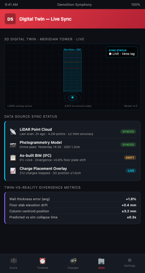
In the Demolition Symphony Planner, the digital twin is the model layer beneath the visual demolition score. When the coordinator notates a charge at Floor 12, Column E, the score queries the digital twin for the as-built geometry at that location — column dimensions, rebar details, concrete grade — and uses those values to calculate the charge weight and predict the fragment cloud. The score is always grounded in the actual building geometry, not the design assumption.
For machine learning charge placement, the digital twin provides the structural feature inputs that the ML model requires: actual column cross-sections, actual material strengths, actual connection geometries. ML models trained on design-drawing data and validated against digital twin data consistently outperform models that use only one data source.
Honest Limits: Cost, Data Gaps, and Adoption Barriers
The practical constraints on digital twin adoption in urban demolition are real. High costs — laser scanning, BIM integration, FE model setup, and licensed simulation software — represent a significant upfront investment that some projects cannot justify (MDPI). For a 10-story building in a suburban site with wide clearances, the cost of a full digital twin exceeds the planning value it adds. The justification threshold rises proportionally with building height, site constraint, and regulatory scrutiny.
Data gaps are the second limiting factor. Buildings constructed before the 1980s often have minimal structural drawings and no electronic record set. For these structures, the laser scan provides accurate geometry but material properties must be estimated from core samples and rebound hammer testing — which introduces uncertainty that the digital twin inherits. A model is only as accurate as its inputs; a digital twin built on estimated material properties is more accurate than no twin, but it should be treated with appropriate confidence intervals in the simulation outputs.
The adoption rate for digital twins in construction more broadly is increasing, and the cost curve is following the standard technology learning curve downward. For urban high-rise implosion — where the regulatory documentation requirements, insurance costs, and safety consequences all scale with building height — the economics of digital twin investment close faster than they do for lower-stakes demolition.
Practical Integration Approach
For coordinators without existing digital twin infrastructure, the recommended entry point is 3D laser scanning combined with a commercial BIM package. The scan captures the as-built geometry; the BIM model attaches structural system data from the available drawings; the resulting model feeds into standard FE analysis software. This does not constitute a full dynamic digital twin in the research sense, but it provides the geometry accuracy that most implosion simulations currently lack. A 3D model implosion simulation built from laser-scan geometry consistently outperforms a simulation built from design drawings on fall-line accuracy, because it starts from the building that exists rather than the building that was intended.
For drone surveillance integration, drone-captured photogrammetry can supplement or partially replace laser scanning for exterior building geometry. Interior structural details still require either destructive investigation or ground-based scanning, but drone photogrammetry substantially reduces the time and cost of exterior geometry capture on tall buildings.
The same BIM-based digital twin framework that supports high-rise implosion planning has been applied to stadium deconstruction planning, where complex roof geometry, multi-level seating bowls, and mixed structural systems create the same as-built documentation challenges — demonstrating that the investment in digital twin infrastructure transfers across demolition project types.
Conclusion
Digital twin technology closes the accuracy gap between what traditional drawings-based planning can predict and what urban demolition regulators now require. Laser-scanned geometry, material-matched FE models, and real-time post-event validation feedback loops produce implosion simulations that are defensible, replicable, and improvable over time.
Urban high-rise implosion coordinators working in dense urban areas — where 40-meter clearances and PPV limits at adjacent occupied structures define the operating envelope — need simulation accuracy that design-drawing models cannot provide. The Demolition Symphony Planner integrates the digital twin as the geometric foundation of the visual score, so every charge annotation is grounded in as-built structural reality. Join the waitlist to see how digital twin implosion accuracy works within the score-based planning workflow.