Integrating Drone Surveillance into Pre-Implosion Site Analysis
What Drone Surveillance Provides That Ground Inspection Cannot
Physical pre-blast structural assessment on a 40-story building faces an inherent contradiction: the floors most critical to inspect — upper floors where structural deterioration may have progressed furthest, and exterior columns where corrosion, spalling, or previous fire damage affects explosive charge penetration — are precisely the floors where safe physical access is most constrained after the building has been vacated and partially stripped. An inspector working from a boom lift can reach perhaps 15-20 floors. Above that, access requires scaffolding that a pre-demolition site does not have and temporary structures that create their own hazards. Drone surveillance pre-implosion site analysis closes this gap: a properly authorized UAV inspection before building demolition begins can complete a full exterior survey of a 40-story building in 4-6 hours, producing actionable data at the element level without exposing a single inspector to elevated-access risk.
Regulatory constraints, confined airspace, and privacy concerns limit drone use in some urban contexts — but these constraints are addressable through FAA Part 107 certification, controlled airspace authorization, and neighbor notification, all of which can be obtained as part of the standard pre-implosion permitting process. The result is that a properly authorized drone operation can complete a full exterior survey of a 40-story building in 4-6 hours, producing a georeferenced point cloud and orthophoto mosaic that documents every face from grade to roof.
The data quality is actionable at the level of individual structural elements. UAV 3D change detection monitors progressive building collapse stages at centimeter resolution, which means a pre-blast drone survey can detect spalled concrete exposing rebar, buckled steel columns from previous fire or overload events, and cracks in shear walls that alter the charge design assumptions. Ground inspection misses these at height; drone inspection finds them before the charge design is finalized.
The Drone Surveillance Framework for Pre-Implosion Site Analysis
Think of the drone survey as the structural score review that happens before the conductor marks a single note in the delay sequence. The demolition score — the floor-by-floor charge map and timing intervals — can only be accurate if the input data reflects the actual structural condition of the building, not the condition assumed from old drawings. The drone survey is the audit that closes that gap.
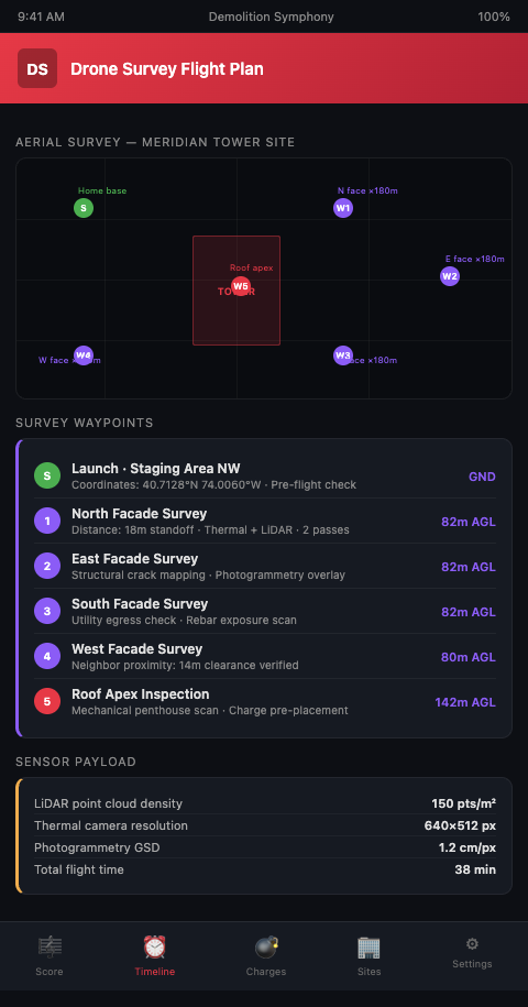
Step 1: Confirm FAA authorization before any flight planning. Commercial drone operations over structures above 400 feet require FAA Part 107 waivers. FAA Part 107 governs commercial drone operations; structures over 400 ft require airspace waivers. Authorization can take 90 days through the standard process; expedited review is available in some cases but is not guaranteed. The drone authorization should be filed at the same time as the implosion permit application — not after the permit is approved. Delay here directly compresses the pre-blast structural assessment window.
Step 2: Plan the survey flight to capture all four facades at all heights. A single nadir (straight-down) flight path does not capture vertical facade elements. Plan a series of orbiting flight paths at multiple altitudes, with the camera tilted obliquely to capture the building faces. Commercial drones used for blast site 3D data capture now execute these flight plans automatically, with commercial drones used for blast site 3D data capture providing reliable repeatability across multiple survey flights. A 40-story building typically requires 6-8 altitude bands with 60-70% image overlap for complete facade coverage.
Step 3: Process the imagery into a georeferenced 3D point cloud. Photogrammetry software processes the overlapping drone images into a dense point cloud and a textured 3D model that allows the structural engineer to inspect any element on any face from any angle, without physical access. The model is georeferenced to the site survey coordinates, meaning that any anomaly identified in the drone survey can be located precisely on the floor plan and flagged in the charge design documentation.
Step 4: Integrate the drone survey findings into the pre-blast structural assessment. The drone survey does not replace the structural engineer's analysis — it provides input data that the structural engineer would otherwise lack. Every anomaly flagged in the drone survey (spalling, corrosion, buckling, crack patterns) should be assessed for its effect on the charge design: does this condition change the explosive weight required to sever this column? Does it change the delay interval required for this floor block? Does it affect the fall direction prediction?
Step 5: Connect drone survey data to the Demolition Symphony Planner score. The pre-blast structural assessment findings inform the charge design; the charge design is the foundation of the delay sequence. When the drone survey identifies a structurally anomalous floor — a level where actual conditions differ from drawing assumptions — that floor's charge group may need revision. In the Demolition Symphony Planner visual score, revised charge groups are immediately visible against the overall sequence context, showing whether the revision creates timing conflicts with adjacent floor groups.
Advanced Tactics: Thermal Imaging, Change Detection, and Integration with Digital Twins
Add thermal imaging to the drone payload for hidden fire damage detection. Concrete and steel that has been exposed to fire retains a heat signature for months after a fire event, even after the surface has cooled. A thermal camera mounted alongside the photogrammetry camera can detect former fire zones on upper floors that were not documented in building records — because the fire was minor, because records were incomplete, or because the building changed hands. Fire-affected structural members have reduced load capacity and require either additional explosive charge or a different sequencing approach to achieve the designed failure.
Use pre-blast and post-blast drone surveys together as a change detection pair. A 2025 survey of UAV-based damage monitoring methods confirms that comparing before-and-after point clouds at centimeter resolution provides precise documentation of what changed, where. For urban implosions where post-blast debris assessment and adjacent structure inspection are required by permit conditions, having a georeferenced pre-blast baseline makes the post-blast comparison defensible and systematic.
Plan drone operations around the window between asbestos clearance and explosive wiring. The optimal window for drone interior inspection — if interior access is needed in addition to exterior survey — is after hazardous material abatement is complete and certified but before explosive wiring begins. Once charges are being installed, interior drone operations become a safety and regulatory concern. Schedule the interior drone survey to complete within this window, even if it requires compressing other pre-blast activities.
Connect drone survey data to the digital twin model for implosion accuracy. A digital twin built from drone photogrammetry data is more accurate than one built from original construction drawings, because it reflects the building's actual current geometry rather than its designed geometry. Any discrepancy between the two — setback dimensions, floor plate areas, column locations — that the drone survey reveals should be incorporated into the digital twin before the collapse simulation is run. Running a simulation on a geometry that differs from the actual building produces a result that is incorrect by exactly the amount of the geometric discrepancy.
Apply the drone inspection framework to sensor-driven adaptive decommissioning scheduling in industrial contexts. Plant decommissioning projects use sensor networks to monitor structural condition in real time during sequential strip-out — the drone-based structural assessment serves the same purpose at the pre-demolition phase. Both approaches replace assumed structural conditions with measured ones, which reduces the risk that the work plan is built on incorrect assumptions.
Document all drone survey findings in a structured inspection report, not just an image archive. Raw drone imagery and point clouds are forensically valuable but not operationally useful without structured documentation. The inspection report should list every anomaly by location (face, floor level, structural element type), describe the observed condition, assess the design impact, and specify whether the charge design requires revision. This report becomes part of the permit file and provides the basis for any charge design modifications that follow the survey.
Survey Every Floor Before You Score a Single Note
Demolition Symphony Planner gives urban high-rise implosion coordinators the ability to connect pre-blast structural survey findings directly to the charge design and delay sequence — so every anomaly found by drone inspection translates immediately into a visible revision in the implosion score. Join the waitlist to see how aerial pre-blast data integrates with the Demolition Symphony Planner planning environment for your next urban high-rise implosion project.
Drone site assessment high-rise implosion planning is not a replacement for a structural engineer's analysis — it is the data collection method that gives the structural engineer complete input. An aerial pre-blast structural survey produces a georeferenced 3D model of the building's actual current geometry, which feeds directly into the charge placement score with element-level accuracy. Drone mapping demolition site geometry before charges are specified ensures that the charge weights, standoff distances, and delay intervals are calculated from the building that exists on site — not the building that was designed 40 years ago and may have been modified, damaged, or deteriorated since. For upper floors that cannot be safely accessed by ground-based inspection, the drone survey is not an optional supplement to the pre-blast assessment; it is the pre-blast assessment for those floors.