Integrating Grove Sensors With Regional Hurricane Center Advisories
The 41-Refresh Problem Coastal Groves Keep Repeating
When Hurricane Milton shifted east between the 5 PM and 11 PM intermediate advisories on October 8, 2024, a Hendry County grove manager tracking the storm through browser tabs lost the last clean window to finish pulling Valencia fruit off the windward rows. The track update moved his packinghouse from "well outside the forecast cone" to "inside the 48-hour warning swath" in under six hours. Payroll for the extra crew was already sent home. The 3,100-box harvest that would have cleared premium juice-plant pricing got downgraded to salvage.
His team had done everything else right. Pre-season packhouse reservation: confirmed. HIP-WI coverage: active. Irrigation system pre-storm checklist: complete. Sensor batteries: all green. The single point of failure was the advisory-consumption pipeline itself — a grove manager, three browser tabs, and a mental model of "the track has not changed much since I last looked." By the time anyone checked the 11 PM intermediate advisory, the track shift had already cost the pull-forward window.
The failure was not the storm. It was the pipeline. Grove managers still consume hurricane advisories through the same browser-refresh ritual they used in 2004, even though the NHC GIS Data via RSS Feeds has been publishing machine-readable bulletins for over a decade. The NHC and CPHC RSS Feeds specification supports basin-wide and storm-wallet subscriptions that hit sensor platforms within 90 seconds of advisory release — four to six minutes ahead of the graphical products most dashboards surface.
Coastal growers watching Valencia, Hamlin, and Murcott blocks during an active track need the 5 AM, 11 AM, 5 PM, 11 PM advisory cadence stitched directly into grove telemetry. A 48-hour salt-aerosol forecast built on the previous advisory is not a forecast — it is a retrospective.
The gap between the official advisory cadence and the intermediate advisories widens the risk. NHC issues intermediate advisories at 2 AM, 8 AM, 2 PM, and 8 PM when a storm is threatening land, which means a grove manager who only checks during daytime hours can miss two overnight advisories that moved the 48-hour track forecast by 20 to 40 nautical miles. That is the window where Hendry County's 23-mile track shift lived — between the 5 PM full advisory and the 11 PM intermediate. Machine-readable ingest closes the gap automatically; manual refresh does not.
The Helm-Charted Yield Forecast Built on Live NHC Streams
HarvestHelm treats the regional hurricane advisory cycle the way a yacht captain treats weather routing: a live chart overlay that updates the helm, not a wall calendar you check on the hour. When an active basin storm enters the 5-day cone that includes your grove's latitude band, the sensor gateway subscribes to the storm-wallet RSS feed and the NHC Active KML Feed, and every advisory triggers a helm-charted yield forecast refresh across your block map.
The integration layer has four jobs. First, fetch the advisory XML within 60 seconds of publication and parse the <pubDate>, storm name, advisory number, position, max sustained wind, and forecast positions at 12/24/36/48/72 hours. Second, compare the new forecast positions against your grove perimeter polygons and calculate updated salt-aerosol exposure for each block using the current wind-field radius. Third, pipe the exposure deltas into the yacht-style helm dashboard so the block map re-ranks hurricane-hour early warning beacons without a manual page refresh. Fourth — and this is where most grove platforms fail — cache aggressively, because the NCEI Data Service API Documentation caps requests at 10,000 per day, which a naive polling loop burns through in under 45 minutes.
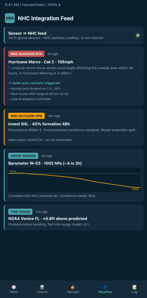
Peer-reviewed work on Integration of smart sensors and IOT in precision agriculture (Frontiers) confirms that sensor-fusion architectures blending grove telemetry with authoritative forecast feeds outperform standalone weather stations on lead-time accuracy. HarvestHelm combines the NHC RSS cadence with on-grove anemometer and salt-conductivity probes, then fuses both streams into a single salt-intrusion canopy triage ranking. Growers see Valencia blocks move up or down the triage list as each advisory lands — the same way a captain watches wind barbs update on a chartplotter.
Critical design detail: your dashboard must distinguish "advisory number increment" from "track significantly changed." Not every advisory moves the cone. HarvestHelm flags advisories where the 48-hour forecast position shifts more than 30 nautical miles or the wind radii grow by more than 15 percent — the thresholds at which block-level salt-aerosol exposure actually recalculates. A grower tracking a slow-moving storm should not get a phone buzz every six hours for a cosmetic update. See our 72-hour hurricane dashboard playbook for how the incident-mode UI surfaces these delta thresholds without alert fatigue.
The NOAA Open Data on AWS supports agricultural practices model proves the pipeline works at scale — BASF Digital Farming uses the same NOAA open-data foundation to train agrometeorological models across thousands of grower accounts. Grove-level integration is the tactical extension of that strategic pattern.
Advanced Tactics: Blending NHC Advisories With Satellite and Commercial Feeds
NHC text advisories lag the underlying model runs. The 5 AM advisory is built on data that closed at roughly 3 AM, and the cone polygon smooths across ensemble uncertainty. Coastal citrus growers on the Gulf side often need the 60-to-180-minute resolution that only comes from blending NHC bulletins with satellite-derived aerosol plume imagery and commercial weather feeds.
Layer satellite salt-plume detection over your block map using the same helm dashboard. Offshore aerosol signatures arriving on a 15-to-45-knot onshore flow hit Valencia rows before the NHC advisory formally updates the wind radii. Our satellite salt plumes workflow shows how to fuse GOES-derived plume data with NHC cone geometry for sub-hour precision.
For groves outside the tropical cyclone belt but exposed to convective wind-and-rain bands, pair the NHC RSS ingest with commercial sources like the Leaf Weather API, which unifies global, local, and hyperlocal forecast models into a single integration surface. Orchard managers in other geographies use the same architecture — mango plantation operators watching convective monsoon development apply the technique to doppler radar alerts for panicle-level spray triggers, proving the sensor-to-advisory pattern generalizes beyond hurricane geography.
Keep your ingest dual-pathway. If the NHC RSS endpoint throttles or goes down — it has — your helm dashboard should fall back to the KMZ network-link feed and flag the degradation visibly. Grove managers who trust a single ingest path during an active track are the ones refreshing browser tabs when the pipeline silently fails.
Regional weather service coordination adds another layer. Local NWS Weather Forecast Offices often issue Special Weather Statements, Tropical Storm Warnings, and county-specific wind advisories that run on a faster cadence than the basin-wide NHC advisory cycle. HarvestHelm parses the WFO text products from the nearest coastal office and surfaces county-level wind-gust forecasts, storm-surge watches, and inland tropical-storm warnings as secondary layers on the helm map. A Valencia block in Hendry County may be 60 miles inland but still exposed to tropical-storm-force gusts that the NHC basin advisory does not explicitly flag at the county level.
Cache Architecture and API Rate-Limit Discipline
The 10,000-request-per-day NCEI cap is only part of the throttling picture. NHC RSS endpoints allow much higher request rates but enforce timeouts under high concurrent load during active tracks — exactly when every grove platform, insurer, and broadcast meteorologist is hitting the same endpoints. HarvestHelm uses a tiered caching pattern: storm-wallet feeds cached at 90-second intervals during active advisories, KMZ network-link feeds cached at 5-minute intervals, NCEI historical queries cached at 24-hour intervals. The cache layer sits between the ingest gateway and the block-level decision engine so a downstream advisory refresh does not trigger a new upstream fetch unless the cache is stale past threshold.
Idempotency is the backing discipline. Every advisory fetch should produce the same block-exposure calculation if the underlying advisory has not changed. HarvestHelm hashes the advisory XML payload and caches the exposure calculation keyed to the hash, so a spurious duplicate advisory (which happens) does not cause the block map to flicker or generate false alert deltas. Grove managers running their own ingest should implement equivalent idempotency or risk alert fatigue from the ingest layer itself.
Webhook delivery versus polling matters too. NHC does not currently publish webhooks for advisory releases, but aggregation services and commercial weather APIs sometimes do. HarvestHelm supports both models — webhook-push for aggregation layers that offer it, fallback polling against the primary NHC endpoints. The hybrid model keeps latency under 90 seconds while staying inside API rate limits across an entire hurricane season.
Stop Refreshing the NHC Page. Start Charting the Helm.
If your grove is running Valencia, Hamlin, Murcott, or Navel blocks within 20 miles of the Atlantic or Gulf coast, manual advisory tracking is the bottleneck between your telemetry and your harvest decisions. HarvestHelm wires the NHC RSS and KMZ streams directly into your block map, refreshes the yield forecast every advisory cycle, and flags only the track shifts that actually change your salt-aerosol exposure. No upfront license. The kilo-cut on successful harvest lines the tool's incentives with the fruit you actually save. Request a coastal-grove pilot before the next tropical wave enters the basin.
Pilots joining the May cohort get their storm-wallet RSS subscription and KMZ network-link fallback validated against the 2 AM, 8 AM, 2 PM, and 8 PM intermediate advisory cadence before the first depression forms, with webhook-versus-polling hybrid ingest calibrated to keep latency under 90 seconds through the full season. Day one of the dashboard shows the 48-hour forecast position delta flagged only when shifts exceed 30 nautical miles or wind radii grow past 15%, eliminating the cosmetic advisory noise that drives 41-refresh fatigue. Groves with both Valencia and Hamlin blocks in Hendry, Polk, or Indian River see county-level WFO Special Weather Statements layered above the basin-wide NHC advisory so inland tropical-storm gusts get flagged before they hit the windward rows.