Scaling Microclimate Sensing Across Multi-County Citrus Operations
The Moment One Grove Becomes Three Counties
A Florida grower we studied runs 1,400 acres across Indian River, St. Lucie, and Martin counties — Valencia blocks on the barrier-island side, Hamlin rows inland along the river, and Murcott blocks pushed further west on higher ground. When Hurricane Ian came up the peninsula in 2022, the operations manager was reading three different salt-aerosol forecasts from three different vendors on three different laptops, then translating each into harvest priority by hand. The Valencia block closest to the Atlantic took salt-spray blackout conditions six hours before the dashboard showed it. The grower lost 12,000 boxes of fruit that was already at 80-count packinghouse size, a size curve that would have cleared the fresh-market premium tier two days later.
The issue was not sensor quality. Each county had functional individual stations. The issue was that no single operator sees the whole exposure envelope as one map. NWS bulletins issue at the regional level and widen the cone over multi-county footprints, so Indian River and Martin blocks get the same alert text even though the storm-surge exposure is completely different. UF/IFAS Precision Agriculture Lab documents this gap: wireless sensors, UAV data, and smart-machinery telemetry exist, but most Florida specialty-crop operators run them as siloed per-block deployments rather than integrated multi-county fabrics. Scaling citrus sensing across counties is not a matter of adding more nodes — it is a matter of stitching disparate coverage into one helm-charted yield forecast.
The Helm-Charted Yield Forecast Framework For Multi-County Operations
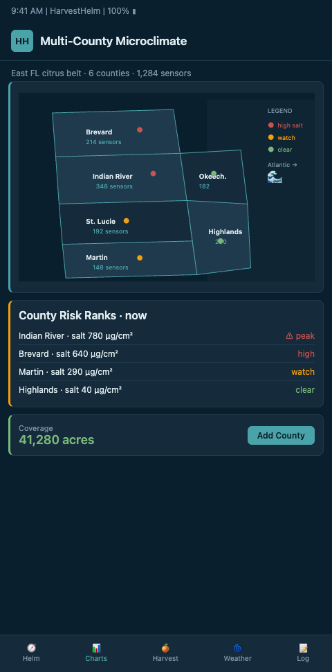
HarvestHelm treats the multi-county citrus operation the way a yacht captain treats a 200-mile offshore passage: as one continuous chart with waypoints, not three separate legs handled by three different crews. The platform consolidates every in-grove sensor, every gateway, every NWS advisory, and every satellite plume overlay into a single helm-charted yield forecast that shows the captain — the operations manager — where salt-spray blackout will hit which Valencia block, with how many hours of lead time, and at what expected brix drop.
Building that chart across counties means solving three architectural problems the single-grove playbook ignores. First, the physical network has to span LoRa-shadowed canopy interiors across tens of miles, so HarvestHelm uses the propagation guidance in the LoRa Communication for Agriculture 4.0 survey — FLog canopy-shadowing models and multi-gateway mesh overlays — to keep packet loss under 3% even in dense Valencia blocks.
Second, the compute has to handle bursty load when a tropical system enters the basin, because every county's packets arrive simultaneously. The cloud-edge-device architecture pattern pushes first-pass salt-aerosol triage and brix projection to edge nodes at each county gateway and reserves the central helm for the yacht-style fleet view. Third, the financial model has to scale linearly with acreage, not with node count, because node count is the primary financial constraint in wireless sensor deployment.
HarvestHelm handles that last constraint through the kilo-cut revenue model: no upfront hardware charge and no per-node license. Growers pay a percentage of the successful harvest, so adding a third county to the operation does not trigger a six-figure CapEx conversation. The Florida Automated Weather Network (FAWN) covers 40+ public stations state-wide as a free backbone, and HarvestHelm layers grove-interior sensors on top — soil-salinity probes in the root zone of each Valencia row, leaf-wetness sensors calibrated for salt-aerosol deposition, and canopy-temperature radiometers that distinguish wind-salt masking from freeze damage. Every probe feeds the same helm so the operations manager at the central office sees Valencia blocks in Indian River and Murcott blocks in Martin on one rotating chart, color-coded by hurricane-hour early warning beacon status. HarvestHelm is the navigator turning three siloed county deployments into one fleet-level yacht helm.
Advanced Tactics For Enterprise-Scale Rollouts
Once the core helm works, enterprise citrus operators can push several advanced tactics. Pair packinghouse throughput data with the grove-level helm so the 80-count cartons on a Valencia block under salt-spray warning automatically trigger pull-forward harvest orders. The ThingsBoard Smart Farming unification pattern — device connectivity, analytics, and dashboards in one stack — applies directly: the helm shows not only the storm track but the packinghouse-ready inventory in the salt-aerosol path. That eliminates the two-dashboard problem the 1,400-acre grower hit in 2022.
The second advanced tactic is staged rollout by adoption readiness. According to McKinsey's Global Farmer Insights 2024, U.S. precision-ag hardware adoption sits at 51%, and large farms above 2,500 acres are 45% more likely to adopt than small. That means multi-county operators can extend sensors into partner groves under contract-harvest arrangements by offering the helm as a shared service — juice-plant contracters and crop brokers get dashboard access to the Valencia blocks they buy from, and the operator gets denser coverage across the region. The kilo-cut model keeps costs aligned: no partner pays until a harvest hits the packinghouse.
Third, tie the helm to the research stack. The UF CREC Citrus Research and Education Center publishes HLB-tolerance data, rootstock salt thresholds, and precision-grove protocols that change yearly. HarvestHelm pulls those feeds into the same chart so a Murcott block newly identified as salt-sensitive gets flagged the next time a tropical system approaches. Operators working across fragmented parcels scaling challenges see the same consolidation pattern pay off across mountain blocks and coastal blocks alike. The result is a multi-county fleet that behaves like a single, well-charted yacht.
Integrating Labor And Equipment Into The Multi-County Helm
A multi-county operation is not only a sensor network — it is a logistics network of picking crews, tractors, spray rigs, bin trailers, and packinghouse staff that have to move between counties on storm timelines. HarvestHelm's helm integrates labor and equipment position data alongside the salt-aerosol overlay so the captain sees where the pick crews are and how long it would take to reposition them from Martin to Indian River when the beacon fires. That integration is the difference between a 38-hour crew mobilization that succeeds and a 38-hour mobilization that stalls because the tractor trailer is 80 miles from the block that needs it.
The labor layer also surfaces availability constraints across the multi-county operation. Florida citrus labor during a hurricane approach competes with neighboring groves, packinghouses, and juice plants for the same H-2A and resident workforce, and HarvestHelm's crew-availability module tracks commitments across the participating operations so the captain knows which crews are genuinely available versus which are on another grove's commitment list. When Ian approached, the 1,400-acre grower in our opening story had crews physically available in Martin County but already committed to a neighbor's Murcott block — a commitment the operations manager only discovered at 03:00 on the day of landfall. The HarvestHelm crew-availability module would have surfaced that commitment 48 hours earlier so the operator could have renegotiated or redirected before the crew was unavailable.
Gateway Redundancy And Canopy Path Planning
The hardest engineering problem in multi-county sensing is canopy-interior packet loss. Valencia and Hamlin canopies at full leaf density absorb 2.4 GHz and 915 MHz signals at rates that catch most single-gateway deployments by surprise — the gateway on the pole at the corner of the 40-acre block gets 98% packet delivery from rows 1 through 12 and 43% delivery from rows 30 through 48. HarvestHelm's multi-gateway mesh layout places a gateway every 8 to 12 rows on a tight grid, with overlap zones that maintain delivery above 95% across the full block.
The mesh handoff is driven by the FLog canopy propagation model, not by line-of-sight assumptions that fail at full canopy. Each gateway also runs a local LTE fallback, so a storm that takes down the primary LoRa path still lets the helm see the block through cellular, and the cellular path runs on a separate carrier profile than the office internet so a county-wide outage does not blind the helm.
The gateway architecture also matters for cost control. A single-gateway deployment covering 200 acres of Valencia canopy typically fails packet-loss thresholds during the September-October peak fruit-load months when canopy density is maximal and every hurricane is bearing down on the grove. HarvestHelm's mesh architecture accepts higher per-block gateway count in exchange for reliable fruit-count telemetry during the critical months, and the kilo-cut revenue model absorbs the gateway cost into the platform fee rather than passing it through to the grower as a line item. The operations manager sees a single subscription-free deployment instead of a project-budget line item that the CFO kills before the first hurricane arrives.
Multi-county citrus sensing is fundamentally a coordination problem, not a sensor problem. Grove operators who try to bolt three single-grove dashboards together will keep losing Valencia fruit in the six-hour lag between regional alert and block-level response.
HarvestHelm compresses that lag by pulling satellite salt plumes and in-grove probes onto one helm chart, and by treating the 72-hour hurricane dashboard workflow as the standard operating picture across every county at once. Coastal citrus growers running Valencia, Hamlin, and Murcott blocks across county lines should ask their current vendors one question: does the dashboard show my whole operation, or just the block I am looking at?
If the answer is the second one, the next hurricane will find the gap HarvestHelm was built to close. The 12,000-box Valencia loss in our opening story was not inevitable — it was the direct cost of three siloed dashboards, and HarvestHelm is the kilo-cut-funded alternative that Indian River, St. Lucie, and Martin county growers should be evaluating before the next named system enters the basin.