Scaling Microclimate Monitoring Across Fragmented Mountain Parcels
The Fragmented Parcel Problem Nobody Talks About
Mountain apple operations rarely look like the contiguous 80-acre Washington blocks most ag-tech demos assume. A typical Appalachian or Hudson Valley grower stitches together six to twenty parcels acquired over three generations — some touching, most separated by a neighbor's pasture, a creek easement, or two miles of switchback road. Each parcel carries its own cold-air drainage signature, and treating them as one orchard-wide yield guess produces the exact cliff-edge harvest planning that wipes out margin.
The scale problem is measurable. A PLOS One study on dense weather networks found that deploying dense station grids reveals large spatial air-temperature variability that undermines single-station irrigation and pest decisions — variability that is invisible when a grower relies on the nearest NOAA station 14 miles downvalley. Block 14 Gala at 1,850 feet and Block 22 Honeycrisp at 2,240 feet behave like different climates on the same bad April night.
Compounding this, a Frontiers review of smart sensor integration identifies fragmented multi-vendor systems as the primary scaling bottleneck. Growers end up with three apps, two dashboards, and zero unified picture of frost pocket behavior across the ridgeline. HarvestHelm was built specifically because block-level growers needed one helm — not fourteen scattered deck screens.
The economics of the problem compound quickly. A 14-parcel Champlain Valley orchard that loses Block 7 Honeycrisp to a cold-drainage event at 3:47 AM will see the frost crew scramble to the wrong parcel first — because without parcel-level alerting, the decision-maker defaults to the parcel they can see from the packhouse. By the time the crew diagnoses which block is actually freezing, the wind machines have lost 40 minutes of effective run time. On a 6-acre Honeycrisp block at $600 per bin, that 40 minutes is the difference between a Grade 1 harvest and a cider-channel salvage. Fragmented parcels without unified telemetry do not just miss events — they actively misdirect crews when events hit.
The Helm-Charted Yield Forecast Approach to Multi-Parcel Rollouts
Think of fragmented parcels the way a yacht captain thinks about a cruising archipelago: each island has its own currents, wind shadows, and shoal risks, but the helm shows all of them on a single unified chart. A helm-charted yield forecast does the same for a mountain orchard spread across 9 miles of ridgeline. Every parcel becomes a navigable zone on the dashboard, color-coded by frost exposure, chill accumulation, and thinning-window status — and every sensor reports through one backbone.
The backbone that makes this work is LoRaWAN. According to the LoRa Alliance Smart Agriculture whitepaper, LoRaWAN gateways support 10-15 km range with multi-year battery life on endpoint sensors. For a grower with parcels scattered across a ridge, this means two or three well-placed gateways — typically at the highest parcel, the packhouse, and a midpoint ridge — can blanket the entire operation with mesh coverage. No cellular SIM per sensor. No per-parcel subscription. One network, fourteen parcels, one helm.
HarvestHelm layers modular station design on top of this mesh. A PMC review of low-cost IoT agrometeorological stations documents how portable modular stations enable localized microclimate assessment for zoned frost protection across scattered blocks — exactly the pattern a 14-parcel Honeycrisp grower needs. Each parcel gets 3-5 sensors (bottom of cold sink, mid-slope, top elevation, plus a redundancy node at the thermal inversion line) and reports back to the helm every 60 seconds during critical frost windows.
Power and durability matter more at scale than at pilot scale. A 3-parcel pilot might tolerate battery swaps twice a season; a 14-parcel rollout cannot. HarvestHelm's sensor nodes use solar trickle charging with lithium-iron-phosphate batteries rated for 10-year orchard deployment, enclosed in UV-stable IP67 housings that survive Hudson Valley winters and Appalachian summer humidity. The hardware decisions that look like overengineering at 3 parcels become baseline requirements at 14 — because the 50-minute drive to replace a battery on the furthest parcel is exactly the friction that kills data completeness in fragmented operations.
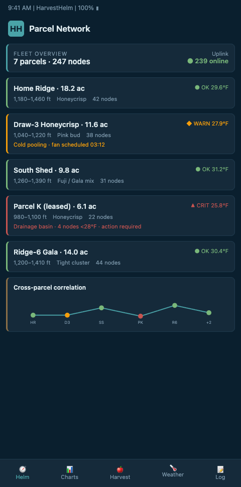
The dashboard then runs slope-level frost pocket mapping at the parcel-by-parcel resolution mountain orchardists actually operate at. Block 14 might show a 29.8F cold-sink reading triggering wind machine deployment, while Block 22 two miles north still reads 34F and requires no action. One helm. Fourteen distinct micro-navigations. Zero guesswork about which parcel needs the frost crew at 3:47 AM.
The National Mesonet Program operates at 1-40 km station spacing as an operational blueprint — HarvestHelm miniaturizes this pattern down to 100-400 meter parcel-level density. The underlying math is the same: more stations, finer resolution, better decisions. A Nature Scientific Reports survey of IoT guidelines details the ESP32/LoRa trade-offs and gateway placement rules that make this miniaturization work across irregular terrain.
The alerting logic is where fragmented parcels become unified operations. HarvestHelm's dashboard routes parcel-specific alerts with GPS coordinates, projected cold-sink fill time, and recommended intervention (wind machine vs over-tree sprinklers) directly to the frost-crew lead's phone. The helm converts 14 separate monitoring problems into one ranked queue: which parcel fires first, which fires next, which is safe to leave alone. On a spring night with a cold-air drainage front moving down the ridge at 20 minutes per elevation band, this ranking is the operational edge that saves the marginal block.
Integration with physical intervention infrastructure is what turns telemetry into yield. Wind machines on Block 14 Gala trigger based on Block 14's local sensor array, not on a regional threshold. Over-tree sprinklers on Block 22 Honeycrisp fire on the block's specific wet-bulb dip, not on a county-average wet-bulb derived from a weather station 14 miles south at 800 feet elevation. This coupling of telemetry to physical response is the reason dense sensor deployment earns its keep — the data drives the actuators that save the crop.
Advanced Tactics for Rolling Out Across Noncontiguous Terrain
The three mistakes that kill fragmented-parcel rollouts are predictable. First, growers over-instrument the easy parcels (the flat ones near the packhouse) and under-instrument the frost-prone outliers — which are exactly the parcels that lose crop. Fix this by deploying sensors in inverse proportion to access convenience: the harder the parcel to drive to, the more sensors it gets. The whole point is not needing to drive there at 3:47 AM.
Second, gateway placement gets treated as an afterthought. A gateway tucked behind a steel equipment shed loses 40% of its range. Place gateways on ridgeline poles at the highest survey point, and run site-survey tests before committing — a ScienceDirect Ag-IoT review covers the scaling bottlenecks that show up when heterogeneous parcels are retrofitted onto a network designed for contiguous fields.
Third, growers try to stitch together multi-vendor hardware before they have one unified data model. This produces the exact silo problem the Frontiers review warns about. Start with a single vendor's mesh, prove it on three parcels, then expand. The audit discipline that underpins this rollout comes from the same playbook as a rigorous sensor coverage audit after a late-spring freeze — you cannot scale what you have not verified parcel-by-parcel. Once the mesh is stable, integrating drone thermal telemetry fills gaps between ground stations and gives the helm a continuous slope view. Operators managing wadi-scattered date groves face a parallel topology problem; the wadi sensor scaling playbook adapts cleanly to mountain ridgeline logistics.
A fourth edge case deserves specific attention: cross-parcel cold-air flow. When parcels are separated by pastures or creeks, cold air does not respect property lines. It drains across the pasture and ponds against the upslope edge of the next parcel. Single-parcel instrumentation misses this effect entirely. Place sensors on the upstream edges of each parcel — the edge facing the next-higher elevation — so the system captures cold fronts moving into the parcel before they reach the fruit zone. A 12-minute early warning on a cold-air drainage front is typically enough to bring wind machines to full RPM before the critical temperature dip.
The data-unification layer is the final piece. Each parcel's 3-5 sensors produce roughly 4,300 readings per day during critical frost windows. Multiply that by 14 parcels and the raw data volume reaches 60,000+ readings daily — unusable without a helm that aggregates, visualizes, and prioritizes. HarvestHelm's backend reduces this firehose to three numbers per parcel on the default view: current temperature trend, projected minimum, and time-to-critical. Growers drill into detail only when a parcel trends toward alert status.
Start Scaling Before the Next Ridge-Spanning Frost
Mountain orchardists running fragmented parcels across elevation bands need one helm, not fourteen. HarvestHelm deploys LoRaWAN mesh coverage across your entire ridgeline with zero upfront cost — we only take a kilo-cut after the packhouse scale clears. Every parcel gets its own microclimate signature on the dashboard, from Block 14 Gala at 1,850 feet to the furthest Honeycrisp outlier two miles up the switchback. Join the HarvestHelm waitlist and lock in mesh-backed coverage for your next frost season before the next cold-air drainage event exposes the gap your current setup cannot see. Pilots signing before the next dormancy cycle get a pre-install ridgeline survey to place the two or three LoRaWAN gateways at the highest parcel, the packhouse, and a midpoint ridge so mesh coverage spans the full 9 miles without cellular SIM per sensor.
Day-one dashboard views reduce the 60,000-plus daily readings across 14 parcels to three numbers per parcel — current temperature trend, projected minimum, and time-to-critical — so the 3:47 AM alert goes to the right parcel with crew dispatch instructions attached. Onboarding includes upstream-edge sensors on each parcel's high-elevation boundary to capture cold-air fronts moving in from neighboring pastures 12 minutes before they reach the Honeycrisp fruit zone, which is exactly the warning the wind-machine operator needs to hit full RPM. The kilo-cut contract settles only on cleared Honeycrisp, Gala, and Enterprise tonnage from mesh-covered parcels, so a gateway tucked behind a steel shed that lost 40 percent of its range costs us before it costs the furthest outlier block. Multi-parcel audits roll up dead zones across all parcels into a single prioritization list, which matters most for growers running parcels across multiple counties where long-tail gaps hide from single-parcel reviews.