Stitching Drone Thermal Flyovers Into Continuous Slope Telemetry
Why a Single Thermal Flyover Is Not Enough
An apple grower flies a thermal-equipped drone at 4:30 AM on a forecast-frost night, captures 1,800 thermal images across Block 14 Gala and Block 22 Honeycrisp, and the images clearly show a 4.2F cold gradient along a dry creek drainage line. Now what? Most orchards file the imagery, use it for a one-time frost map, and never operationalize it. The ground sensors continue to report point-data that misses the channel. The next freeze, the same cold-drainage lane hits, and the same fruit zone suffers.
The problem is not thermal imaging. Drone thermal is genuinely powerful. MDPI Remote Sensing's study on UAV heating requirements for frost management shows that BRISK-feature thermal stitching yields sub-centimeter georeferenced orchard temperature maps for frost planning — the fidelity is there. The problem is that a single flyover is a snapshot, and frost navigation is a continuous process. Without stitching flyover data into the ongoing sensor telemetry stream, the grower owns a beautiful map of one cold morning and zero infrastructure for the next one.
Worse, the technical challenge of stitching thermal images is underrated. Another MDPI Remote Sensing study on orthomosaicking thermal drone imagery documents that low-contrast thermal imagery breaks mesh-based stitching — RGB-guided surface mesh is needed to compensate. Growers who try to stitch thermal flyovers with consumer-grade workflows end up with seam artifacts and position errors that make the output unusable for decision-making.
The contrast problem is fundamental to thermal imagery. Unlike RGB imagery which typically has high scene contrast from color variation, thermal imagery of an orchard at pre-dawn shows relatively uniform temperatures across most of the canopy with just a few degrees of variation. This low-contrast signal provides insufficient feature points for standard structure-from-motion algorithms. The result is mosaic seams that do not align, leaving the grower with an artifact-heavy map that cannot be trusted for siting wind machines or placing sensors. Professional thermal workflow requires radiometric calibration passes, RGB-cosine pairing, and ground-control-point verification to produce usable output.
The Helm-Charted Yield Forecast Approach to Fusing Drone and Ground Telemetry
Think of stitching drone thermal flyovers into continuous slope telemetry the way a yacht captain thinks about integrating radar sweeps with continuous AIS data: the radar sweep is a wide-area snapshot every few minutes; AIS is a continuous ping from specific vessels. Neither replaces the other, but together they produce a navigational picture that is more accurate than either alone. A helm-charted yield forecast fuses thermal flyover grids with ground-sensor point streams into a single unified slope-telemetry layer.
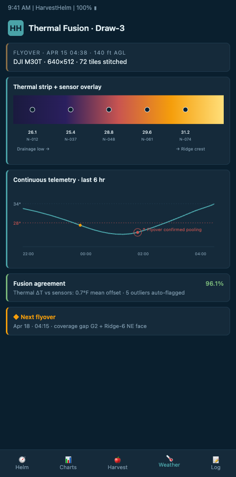
HarvestHelm's workflow flies thermal UAVs on a calibrated pass during known cold-air drainage events, processes the imagery through a gradient-descent self-calibration step — grounded in the approach from MDPI Drones' self-calibration UAV thermal gradient descent study — and georeferences the output against ground-truth station readings. The thermal grid then becomes an interpolation surface that fills the gap between point sensors. When a ground sensor at the top of Block 22 reads 32.1F and another at the bottom reads 28.4F, the thermal grid shows the exact gradient in between rather than forcing the helm to linear-interpolate through a cold-sink channel that does not behave linearly.
The flight planning is event-driven, not schedule-driven. The helm watches for meteorological signatures of strong cold-air drainage (clear skies, wind speeds below 3 mph, dewpoint depression above 8F) and triggers a flight authorization window when those signatures align. A pilot on standby flies during the critical pre-dawn window, captures 800-1,800 thermal images with 75% overlap, and delivers raw imagery for same-day processing. By 10 AM, the stitched thermal map is integrated into the helm alongside the ground-sensor readings from the same night — a precisely-timed coupling that cannot be replicated by monthly or scheduled flyovers.
The Springer Precision Agriculture study on high-resolution UAV thermal demonstrates single-tree thermal assessment in commercial orchards — the fidelity resolution is tree-by-tree, which means stitched thermal grids can resolve drainage lanes that split a block down the middle. The Penn State ETDA UAV multi-dimensional mapping framework lays out the frost-management architecture for mapping exactly this kind of micro-gradient. This matters because a cold drainage lane that cuts diagonally across a block cannot be mitigated by wind-machine siting that assumes the block behaves as a uniform unit — the lane needs its own dedicated wind machine or sprinkler coverage, and the thermal map is the only way to see it.
Flight planning and radiometric calibration are where most DIY thermal stitching fails, and where professional workflows earn their keep. Frontiers' work on UAV thermal flight planning details the flight-planning and radiometric-calibration requirements for accurate UAV thermal orthomosaics — 70-80% overlap, calibration boards before and after each flight, and wind-speed tolerance windows. HarvestHelm standardizes these parameters so each flyover produces imagery compatible with prior flyovers, allowing year-over-year differencing that reveals drainage channel drift as trees grow, equipment sheds shift, or wind machines are added.
Once stitched, the thermal layer integrates directly with the live sensor dashboard. A 3:47 AM frost event does not require a new flight — the helm already knows where the cold drainage lanes are and overlays the current ground-sensor readings on the prior thermal map. If the overlay shows a cold lane pushing fruit temperatures below critical thresholds faster than expected, the wind machines on that lane fire early.
This fusion model solves the economic problem of thermal drone operations. Flying a full thermal flyover costs $400-$1,200 per hour between drone operator time, equipment amortization, and post-processing. At a frequency of 4-6 flyovers per season, the annual cost is significant. But because each flyover contributes to a permanent thermal baseline layer, the cost amortizes across years rather than being re-incurred each flight. Orchards that treat flyovers as one-off events pay the full cost every time. Orchards that fuse them into continuous telemetry pay once for the baseline and then only for targeted updates when terrain or vegetation changes.
Advanced Tactics for Continuous Slope Telemetry
Three advanced plays separate orchards that actually operationalize drone thermal from those that just fly it. First, flyover cadence should be tied to specific meteorological triggers — clear, calm nights with radiative cooling potential — not calendar dates. One well-timed flyover on a strong inversion night produces more actionable data than twelve flyovers on marginal nights.
Second, georeferencing RMSE must be benchmarked against ground-truth. MDPI Remote Sensing's UAV orthomosaic georeferencing benchmarks establish the RMSE thresholds that make thermal data usable for sensor-layer fusion. Sub-meter georeferencing is the minimum; sub-30cm is better. Without this discipline, the stitched thermal grid cannot be reliably aligned with ground sensors.
Third, year-over-year differencing is the payoff. A drainage channel that shifts 15 meters downslope over three years signals a tree-growth or terrain-change effect that is invisible in any single flyover. Build the archive and the diff becomes a navigational asset.
A fourth advanced tactic: combine thermal flyovers with phenology imagery. A single flight can collect both thermal and RGB multispectral data on the same pass, producing aligned maps of temperature distribution and bloom stage. Growers can see which cold pockets intersect with which bloom-timing zones — critical because a cold pocket that only fires during dormancy is low-risk, while one that fires during pink-bud stage is high-risk for the same blocks. The helm layers these maps so the risk ranking is phenologically informed rather than just temperature-informed.
This workflow anchors the broader microclimate parcel scaling problem because thermal layers can bridge parcels that are too scattered to instrument densely with ground sensors. It also validates the hyperlocal drainage overrides to regional NOAA alerts, where block-level drainage data routinely contradicts the regional forecast. Coastal citrus groves apply a parallel satellite-based remote-sensing layer for brine events; see satellite salt plumes for the cross-niche analog to continuous slope thermal telemetry.
Regulatory compliance deserves explicit mention. FAA Part 107 rules apply to commercial UAV operations, and night flights (the most valuable window for frost-related thermal imagery) require specific waivers that take weeks to secure. Operators without standing night waivers cannot execute event-driven flights on the timing required for useful frost data. HarvestHelm's network of contracted Part 107 pilots includes operators with standing night and beyond-visual-line-of-sight waivers for specific orchard regions, so the regulatory lag does not compound onto the meteorological timing constraint.
Turn Your Next Thermal Flight Into Permanent Infrastructure
Mountain orchardists who have flown drone thermal before know it shows drainage channels ground sensors miss — but turning that flyover into continuous slope telemetry requires stitching, calibration, and ground-sensor fusion. HarvestHelm handles all three as part of the helm-charted yield forecast deployment. Your next thermal flight becomes a permanent layer on your dashboard, not a one-off map that gets filed. Zero upfront cost — we only take a kilo-cut after the packhouse scale clears your harvest. Join the HarvestHelm waitlist to lock in thermal-fusion coverage for Mountain Apple Orchards ahead of the 2026 frost season and turn years of drone imagery into a single navigable chart of every drainage lane on your ridge.
Pilots signing before the next inversion season get access to the contracted Part 107 pilot network with standing night and beyond-visual-line-of-sight waivers already filed for your orchard region, so event-driven pre-dawn flights happen within hours rather than weeks. Day-one dashboard views fuse the stitched thermal grid with your ground-sensor point streams into a single slope-telemetry layer, with georeferencing RMSE benchmarked sub-30-cm against ground-control points. Onboarding includes event-triggered flight authorization windows watching for clear skies, wind under 3 mph, and dewpoint depression above 8F, so imagery lands on the helm by 10 AM the same morning the cold-drainage lane formed.
The kilo-cut contract settles only on cleared Honeycrisp, Gala, and Enterprise tonnage from blocks where the thermal-fusion layer informed wind-machine siting or sprinkler coverage, so a 4.2F cold gradient along a dry creek bed that the helm missed costs us before it costs your fruit broker's contract. Year-over-year differencing surfaces drainage channel drift as trees grow or equipment sheds shift, making the thermal archive compound in value across a decade rather than expiring with each flight.