When Cold-Air Drainage Overrides Regional NOAA Apple Alerts
The NOAA Advisory That Missed an 11-Block Freeze
A Hudson Valley grower received a NOAA frost advisory for "widespread minimums near 32F" on a May bloom night and decided the orchard-wide fans could stay off — the threshold was above the Honeycrisp kill temperature. On-site probes told a different story. By 2:30am, 11 basin blocks had dropped to 27F on katabatic drainage into a narrow ridge-to-valley alignment that the NOAA grid averaged out of existence. By dawn, the grower had lost over 30% of king bloom in those 11 blocks. A NOAA Climate.gov analysis of single-cold-day impacts on Northeast apples documents that a single freeze below 28F at bloom can wipe out a region's apple crop — and the regional alert system does not model the slope-level dips that create those freezes.
The grid coarseness is the structural problem. The Northeast Regional Climate Center's apple frost risk tool uses a 2.5-mile grid interpolated from NDFD and Rapid Refresh forecasts — state-of-the-art for the region, but still coarser than a single slope. And a National Weather Service overview of the Frost/Freeze Program acknowledges the limit: NWS issues advisories and warnings at threshold temperatures but does not model slope-level cold-air drainage at any station. That physics — gravity-driven cold air flowing downhill at night — is exactly what a mountain orchardist has to manage.
The coarseness matters most in mountainous regions with narrow valleys. A 2.5-mile grid cell that spans a ridge top at 1800 feet and a valley bottom at 900 feet reports a single temperature estimate — typically the mid-slope average — that can miss either extreme by 5F or more. A grower whose orchard sits in the valley bottom of such a cell sees NOAA forecast 32F while their own probes read 26F, and the difference is not sensor calibration; it is real cold-air pooling the grid cannot resolve. Mapping that pooling before the override decision even comes up is foundational work — a cold-air drainage map methodology walkthrough covers the IoT probe placement that seeds the per-block override profile, so the grower knows which blocks will diverge from NOAA before the first frost night of the season.
Override Logic on the Helm-Charted Yield Forecast
HarvestHelm's override logic is built directly into the helm-charted yield forecast. The system ingests the NOAA grid forecast for the orchard's cell and runs it alongside the on-site probe network in parallel. When the two diverge by more than 2F at the coldest probe, the override trigger fires, and the helm display switches the block's decision source from the regional forecast to the local probe. The yacht metaphor is apt — a captain near shore does not trust the open-ocean weather forecast when the depth sounder says 4 feet under the keel. Local readings override the regional model when the geometry demands it.
The katabatic physics is well-documented. Britannica's entry on katabatic wind describes gravity-driven slope drainage that occurs at night as highlands radiate heat — and the local signal is invisible at METAR stations sited on flat ground. The AMETSOC Glossary's authoritative definition of katabatic wind is more formal: a downslope wind formed by local radiative cooling, diverging from synoptic flow. That divergence is the exact phenomenon that makes NOAA alerts unreliable on mountain parcels.
The override does not mean ignoring the regional forecast. It means using the forecast as the baseline and the probe network as the correction. Cornell Climate Smart Farming's apple stage and freeze damage probability tool pairs click-map location-specific kill probability with the NC chill unit model to give a location-weighted forecast — and a Cornell Chronicle article on the tool's release notes it accounts for topographic temperature variation not represented in coarse station observations. HarvestHelm feeds the Cornell tool's output into its forecast panel alongside the in-canopy probes, so growers see three signals — NOAA grid, Cornell topographic adjustment, and on-site sensors — and understand when each matters.
The three-signal display is structured as a yacht chart overlay. The NOAA grid forecast shows as the background contour (regional weather baseline), the Cornell topographic adjustment shows as a refinement layer (slope-adjusted regional), and the in-canopy probes show as live waypoints (ground truth). Growers quickly learn to read the three layers together — a probe reading that matches the topographic refinement but diverges from the raw NOAA forecast means the model is working as designed; a probe reading that diverges from both means something unusual is happening and the override should fire.
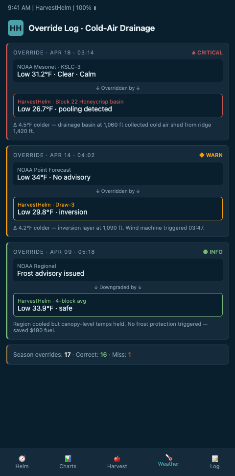
When to override is a specific set of conditions. HarvestHelm's override engine fires when three criteria align: dew point is low (under 35F, indicating radiation-frost conditions), wind speed is under 3 mph (allowing cold air to pool), and at least one probe in a known cold-sink location reads 3F below the NOAA forecast. These three criteria together signal that the regional forecast has missed the slope-level dip. A Growing Produce article on the NRCC's apple freeze risk tool acknowledges that the grid-based regional tool still requires grower ground-truth when a site drains cold onto a valley floor — HarvestHelm automates that ground-truth check.
The override trigger log is part of the value. Every night where the override fires is logged with probe readings, dew-point trajectory, wind speed, and the regional forecast at the time. Over 2-3 seasons, this log builds a parcel-specific record of how often and how severely the NOAA grid under-reports for each block. Growers can see that Block 22 at the basin bottom diverges from NOAA by an average of 4F on 30% of frost nights — a pattern that justifies both dedicated probes and a permanent override profile for that block.
Advanced Tactics for Regional-Local Signal Arbitration
The override logic needs to handle the reverse case too — when on-site probes read warmer than the regional forecast because the parcel sits above the inversion layer rather than below it. In that scenario, the NOAA alert is still the right signal because a ridge-top block can drop suddenly when the inversion lifts at dawn. HarvestHelm's logic tags each block with its position relative to the basin (ridge, mid-slope, basin) and applies the override asymmetrically: basin blocks trust probes more when colder; ridge blocks trust forecasts more when colder.
Sunrise dynamics deserve special attention. The inversion typically breaks 30-60 minutes after sunrise, and ridge blocks that stayed warm through the night can drop 5-8F in 15 minutes as the inversion lifts. HarvestHelm's dawn-transition mode watches the probe network and the forecast together during the hour before sunrise and the hour after, and escalates alerts when the inversion breakdown threatens ridge blocks that were not previously flagged. This is the window where the NOAA forecast is often the better signal because the regional model captures the broader atmospheric transition that probes alone cannot see.
Historical divergence tracking improves the override over time. HarvestHelm logs every night where the regional forecast and the on-site probes differed by more than 2F, and builds a divergence fingerprint per block. Blocks with consistent cold bias get their override thresholds lowered; blocks with consistent warm bias get their fan triggers lifted. This is the same machinery that informs preventing false-positive frost alerts on south-facing blocks — the override engine is the other side of the false-positive problem.
Mapping the drainage itself is the foundational work that feeds everything downstream. The per-block override profile discussed earlier is built from the drainage map, not inferred from aggregate probe readings — a block's divergence from NOAA is a property of its position in the basin geometry, and that property has to be captured before override thresholds can be set intelligently.
The principle generalizes to other regional-local mismatches. Tropical mango growers face NOAA monsoon withdrawal forecasts that miss canopy-internal humidity dynamics — a different physical phenomenon but the same regional-versus-local arbitration problem. HarvestHelm's sister approach for canopy humidity versus monsoon withdrawal applies the same override machinery to fungal-pressure decisions rather than frost decisions.
Forecast model selection matters for the override quality. NOAA's NDFD uses high-resolution Rapid Refresh (HRRR) output during the short-range horizon and blends to GFS for longer horizons. The short-range HRRR is typically more accurate for cold-air-pool formation, so HarvestHelm weights the HRRR output more heavily than the GFS blend during the overnight frost window. The weighting is configurable per parcel because some high-altitude sites have documented biases in HRRR output that growers have validated against their own probes over multiple seasons.
The failure mode to avoid is chronic override. A grower who overrides NOAA every night loses the value of the regional forecast as a planning horizon. HarvestHelm caps automatic overrides at nights where the three-criteria trigger fires, and flags any pattern of more than 40% override frequency as a probe-calibration issue worth investigating.
Ready to Override NOAA When Your Slope Says So?
Mountain orchardists relying on regional alerts are losing buds to cold-air drainage the NOAA grid does not see. HarvestHelm runs the NOAA feed, the Cornell topographic tool, and your in-canopy probe network in parallel, and automates the override decision when slope-level data diverges from the regional forecast. Zero cash upfront — kilo-cut at packhouse scale only. Tell us your parcel's elevation range, aspect mix, and which nights last spring felt colder than the forecast when you join the waitlist, and we will build your first override profile against those specific events. Pilots signing before bud-swell capture at least two low-wind, low-dew-point radiation-frost nights before bloom, which is what the override engine needs to tag a block's divergence pattern against the NOAA grid cell.
Day-one dashboard views layer the NOAA grid forecast, the Cornell topographic refinement, and your in-canopy probes on the same three-signal overlay, with the override trigger threshold drawn at 3F below the regional forecast at the coldest sink probe. Onboarding includes the dawn-transition mode that watches ridge-top Honeycrisp and Enterprise blocks during the inversion break, which is when the NOAA signal is usually the better one and probes alone would mislead. The kilo-cut contract settles only on cleared Honeycrisp, Gala, and Fuji tonnage from blocks where the override logic was the active decision source, so a chronic-override pattern that indicates probe drift gets flagged before it costs packhouse grade. HRRR weighting in the forecast blend is configurable per parcel so high-altitude sites with documented Rapid Refresh bias can tune the override without HarvestHelm touching the engine.