Building Your First Cold-Air Drainage Map With IoT Soil Probes
A Single Calm Night Reveals Your Orchard's Cold Current
The cold air flowing down your slope at 2 a.m. on a clear April night is behaving like a dense fluid obeying gravity. Britannica's entry on katabatic wind defines exactly this: downslope cold-dense air flow driven by gravity and radiative cooling. On a single calm radiation night, an IoT probe grid can capture that flow and produce a drainage map more precise than any regional advisory will ever give you. Most orchardists never capture that data. They react to frost events after they hit, tuning wind machines and sprinklers after damage is already landing.
Research published in MDPI's atmosphere journal on distinguishing katabatic flow timescales demonstrates how distributed temperature sensing can map fine-scale katabatic drainage over complex terrain. Mountain apple orchards are textbook complex terrain — the physics the researchers describe is happening on your slope every clear night below 40°F. The question is whether you have the probe grid to see it.
A second research foundation: American Meteorological Society work on nocturnal surface inversions shows how stable nocturnal inversions stratify the air in cool nights, creating the conditions where cold pools form and settle. Your drainage map needs to capture both the flow path (where air moves downhill) and the sink (where stratification leaves it pooled). Penn State's frost protection research adds the threshold: calm 1-2 mph winds let cooled air pool several degrees below ambient, which is exactly when your probe grid should be logging at minute resolution, not hourly.
Building the Map With a Helm-Charted Probe Grid
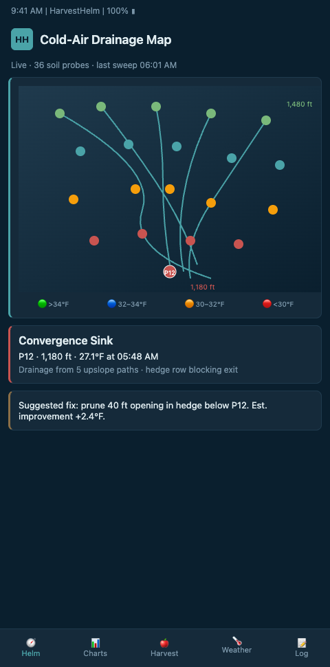
Think about the drainage map as the chart a yacht captain builds before entering an unfamiliar anchorage. They do not memorize every depth reading — they mark the depth breaks, the current vectors, and the hazards. A helm-charted yield forecast for a mountain orchard does the same thing, but for cold air instead of water. You are mapping where the cold current flows, where it pools, and where it re-emerges on the next slope. HarvestHelm builds that chart with IoT soil probes modified for air-temperature logging at canopy height.
Start with probe selection. Standard IoT soil probes — the same ones used for moisture monitoring — can be adapted for air-temperature drainage mapping by adding a shielded thermistor at 1.5 m above the stake. The FrostBoss explainer on katabatic drift notes that orchard row orientation can favor or obstruct natural drainage, so your probe layout needs to match the flow direction of the slope, not the orientation of the rows.
Place probes on a three-tier hierarchy. Tier one: ridge reference. One probe at the highest point of the block, upwind of prevailing cold-air flow. This is your baseline. Tier two: flow-path probes. Place probes every 75-150 feet along the suspected drainage corridor, starting at the ridge and running to the bottom of the slope. Tier three: sink probes. At each suspected cold-air pooling location — bottoms of terraces, upstream of stone walls, upstream of windbreaks — place one probe on the floor of the sink and one paired probe 15-25 feet upslope. This paired setup is what confirms the pool is real, not geometry.
Record probe GPS coordinates and elevations at install — within 1-meter precision if your receiver supports it. The drainage map's accuracy depends on knowing where each data point actually sits on the slope, and this record becomes essential when you add probes in later seasons or when you need to replace a failed probe at the exact same elevation.
Run the grid for a full dormant season. On the first clear, calm night with forecast minima below 35°F, watch the minute-resolution data come in. You will see the ridge probe cool at one rate, the flow-path probes cool at successively slower rates as air pools, and the sink probes drop fastest of all. That pattern — a cascade of cooling rates down the slope — is your first drainage map. The research from Kansas Mesonet on inversions walks through how to detect, measure, and forecast temperature inversions using exactly this kind of probe data.
A practical note on probe spacing: the research suggests that too-close probe placement (under 50 feet apart) produces redundant data that inflates infrastructure cost without adding decision value. Too-wide spacing (over 200 feet on a slope with more than 10% grade) misses the sink edges that matter most. The 75-150 foot band is what research shows balances coverage with cost for mountain terrain. Start there; adjust after one season of data shows where gaps exist.
IoT microclimate research covered in ScienceDirect's review of IoT microclimate monitoring describes real-time systems that handle exactly this kind of spatial temperature stratification, feeding it into irrigation and alert dashboards. HarvestHelm runs the same architecture but tuned to orchard-specific decisions: which sink crosses freezing first, how long it stays there, and whether the inversion is strong enough to make wind-machine operation worthwhile. The frost pocket mapping walkthrough covers the broader pre-bud-break workflow that the drainage map feeds into.
Advanced Tactics: From Map to Decision Rules
Once the first drainage map is built, the next step is turning it into decision rules. The map itself does not save fruit — decisions do. Start by encoding three thresholds per sink: one for advisory (wind machine standby), one for action (sprinklers on), one for critical (every crew member deployed). Tie each threshold to the pair-probe delta, not to the absolute temperature, because the delta is what tells you the inversion is actually forming.
The first common mistake is treating the drainage map as static. Drainage paths shift when hedgerows grow, when downslope neighbors clear land, and when you add or remove equipment sheds. Re-validate the map every two seasons minimum. The second mistake is ignoring NOAA's regional forecasts when they disagree with your probe network. In mountain terrain, your probe network is almost always right — and the drainage overrides NOAA discussion walks through when and why local probe data trumps regional advisories.
Third advanced tactic: watch for inversion-strength signals. A strong inversion means your wind machines can mix warmer air from above down to fruit height; a weak inversion means wind machines do little. The pair-probe delta is your inversion-strength reading in real time. Your dashboard should compute it and color it, so you are not running wind machines during weak-inversion nights when their return on diesel is negative.
This drainage-mapping approach — paired probes feeding a helm-charted forecast — transfers to other canopy microclimate problems. Growers tracking flush-bloom humidity timeline on tropical mango plantations use the same paired-probe logic to capture in-canopy humidity variance, which is essentially the same problem in a different fluid medium.
A fourth advanced tactic: integrate drainage-map telemetry with wind-machine and sprinkler control logic. Instead of firing every protection asset across the orchard when the regional advisory hits, fire only the assets in sink zones flagged by the current probe network reading. A typical 40-acre mountain orchard has 3-5 distinct sink zones; lighting up wind machines for all of them costs 5-10x more diesel than lighting up the two that are actually cooling dangerously. The drainage map makes this level of targeting possible.
A fifth: link drainage telemetry to your insurance documentation. When a frost event damages Block 14 Gala, the probe record of the sink-zone temperatures, timestamps, and durations becomes the evidence file for your claim. Insurers routinely underpay mountain-orchard claims because growers cannot document the exact event conditions. The probe network solves that documentation problem in the background.
A sixth tactic: share the drainage map with neighbors at property boundaries. Cold air flowing off your slope often affects the neighboring block's fruit set, and vice versa. A shared map of drainage corridors across property lines helps coordinate windbreak maintenance, new plantings, and even shared wind-machine deployment. Many mountain orchards are close enough that cooperation on cold-air management produces better results than parallel individual efforts.
A seventh tactic specific to orchards considering expansion: use the drainage map to qualify or disqualify candidate replant blocks. A block that sits downstream of a major discharge path is a high-risk expansion candidate regardless of how good the soil is. The map tells you this before planting stock is ordered — an input traditional scouting simply cannot provide.
Put the Map on Your Helm Display This Season
Mountain apple growers still reacting to frost instead of navigating it should make this dormant season the one you build your first drainage map. HarvestHelm onboards mountain orchardists, elevation-band growers, and packhouse operators who want real katabatic flow data under their Honeycrisp and Gala blocks before next bud break. We install the three-tier probe grid, deliver the drainage map as a living layer on your dashboard, and take a kilo-cut only after packhouse scale receipts — so the map is built before the cost of being wrong hits. Apple brokers contracting with mountain growers benefit too: the map becomes a de-risking signal for the supply agreement.
First-season onboarding targets one calm radiation night under 35 degrees before bud-swell, which the ridge-reference probe plus flow-path and sink probes capture at minute resolution across every suspected discharge corridor. Day-one dashboard output shows the cascade of cooling rates from ridge to sink, with pair-probe deltas colored by inversion strength so wind-machine operators know which nights justify diesel and which do not. Pilots signing ahead of January also get a shared drainage map for cross-property discussions with neighboring orchards, since cold air draining off a Gala block at 2,100 feet often pools in a neighbor's Honeycrisp at 1,850 feet. The onboarding contract explicitly ties the kilo-cut trigger to the season the drainage map actually prevents a frost loss, so the first-year map build sits inside the same kilo-cut structure with zero upfront cash.