How to Map Frost Pockets on a Mountain Apple Orchard Before Bud Break
The Silent Third of Your Crop Lost Before You See Bloom
In 2012, New York apple growers lost 60% of their crop after an unusually warm March pushed bud break three weeks early, only for a May frost to catch half-advanced tissue unprotected, as documented in a Scientific American report on climate and apple harvests. That season was not a statewide wipeout — it was a block-level wipeout. Orchards on the wrong slope aspect, with frost pockets no one had mapped, lost nearly everything, while neighbors 200 feet higher and 400 feet away pulled a full harvest.
That gap is the story of mountain apple growing. Cold air behaves like water, flowing downhill under gravity and pooling in low spots, as the FAO Frost Protection Manual has documented for decades. The Rutgers NJAES bulletin E363 extends that finding: windbreaks, stone walls, hedgerows, even old equipment sheds can dam cold-air flow, turning a gently sloping block into a sink.
Most mountain orchardists already know their worst frost pocket. They watched Block 14 Gala lose half its fruit in 2018 while Block 22 Honeycrisp — 120 vertical feet higher — came through clean. But knowing is not mapping. A narrative memory of frost events does not help you decide where to run over-tree sprinklers, where to stage wind machines, or which acre of new plantings to move. You need a spatial record tied to temperatures, timestamps, and elevation bands. That is the map this article will teach you to build, one that is ready before bud break tightens every decision window.
The financial stakes push the decision further. A single-event 30% frost loss on a 40-acre Honeycrisp block at current packout prices translates to six-figure damage — and insurance often covers a fraction at best, because mountain orchards with known frost pockets are priced in to policies. The unmapped pocket is a deductible event that keeps recurring. Mapping it once, before bud-swell, is the first cost reduction available to mountain growers that does not require new capital equipment.
Charting the Slope Like a Yacht Captain Reads Coastline
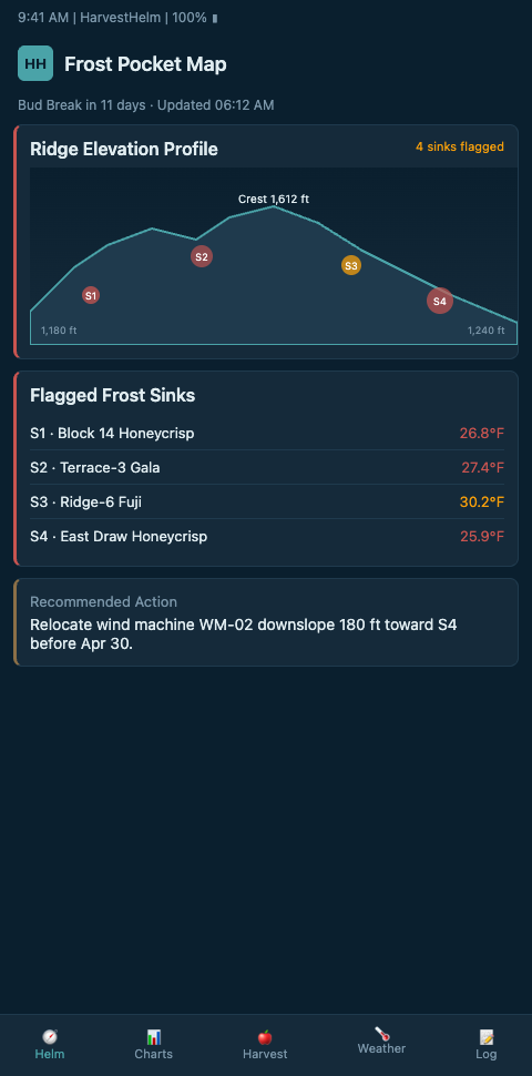
The clearest way to think about pre-bud-break frost mapping is to borrow from nautical navigation. A yacht captain entering an unfamiliar harbor does not rely on the sea looking calm — they read charted depths, current vectors, and known hazards laid out on the helm display. The slope of a mountain orchard is your harbor. The cold-air flow down its contours is the current. Frost pockets are your reefs. A helm-charted yield forecast replaces the captain-by-feel approach with layered data: elevation, aspect, air drainage paths, historic frost events, and current sensor readings. HarvestHelm builds exactly that display for orchards.
Start with the physical survey. Walk the block on a clear, calm morning in late winter, ideally one hour before sunrise when radiation cooling peaks. Penn State Extension research shows calm 1-2 mph winds let cooled air pool several degrees below ambient, so that is the window where pockets reveal themselves. Carry a handheld thermometer and take readings at every elevation break, every change in row orientation, and at each edge of a windbreak or tree line. You are building a first pass — not final — frost map.
Next, layer elevation. Penn State notes that each 100-foot rise yields 5-10°F warmer spring night temperatures during radiation frost events. That means a 400-foot elevation change across your orchard can create a 40°F difference in coldest-night minima between a top bench and a bottom basin. Mark the contour breaks. A simple LiDAR dataset from your state GIS portal is enough — you are not building a topographic masterpiece, you are naming the stairs cold air walks down.
Add the sensors. Extension guidance from Montana State on apple orchard site selection emphasizes that elevation alone does not guarantee good air drainage — obstacles matter as much as gradient. So place two tiers of IoT probes: one at each suspected pocket floor, another 15-25 feet upslope. The delta between paired sensors over a single inversion night tells you whether that low spot is actually a sink or just geometry. If you are designing that probe network from scratch, the cold-air drainage map walkthrough covers probe depth, power, and telemetry decisions.
Run the probes through two full dormant seasons before you lock the map. One season captures a typical event profile, but two seasons capture the variance — a mild winter and a cold winter, or an early bud-break year and a late one. The second-season probe data is what refines your confidence intervals on where the pocket edges actually sit. Growers who lock the map after one season frequently re-plant sensors the next year; growers who run two seasons of telemetry rarely re-spec hardware.
Finally, validate with UAV thermal. Research from MDPI's remote sensing journal on UAV heating requirement mapping shows thermal imagery can generate heating requirement maps for variable-rate frost irrigation — essentially pre-building the map of where sprinklers, wind machines, or simply no-plant zones should go. One thermal flight before bud break costs less than one lost bin of Honeycrisp.
The layered view that emerges is what we mean by a helm-charted yield forecast. Your dashboard shows the physical slope as a navigation chart: probes tagged by role, drainage corridors drawn as flow lines, sink points flagged with historical frost-event severity, and current overnight temperature deltas updating in real time. The captain analogy matters because the decisions happen in short windows — fire up the wind machine or wait, run sprinklers now or hold, pull a cover or leave it. You cannot make those calls from a narrative; you make them from the chart.
Scaling the Map Across Blocks and Seasons
Once you have one block mapped, the temptation is to stop. Do not. Frost pockets shift when you remove a hedgerow, when a neighbor clears a downslope tree line, when a new shed goes up on the access road. The map needs to be living. That is where HarvestHelm changes the economics — because we only take a kilo-cut of cleared harvest, there is no upfront cost to keeping probes live year after year, so the incremental cost of adding a sensor to Block 14 this spring is effectively zero until the crop actually lands on the packhouse scale.
The most common mistake mountain orchardists make in pre-bud-break mapping is treating the map as static. A second is weighting probe data equally across elevation. The bottom-of-basin probe in your coldest pocket is a different kind of data than a mid-slope probe — it is a warning system, not an average. Tag probes by role when you set them up: sink, edge, reference, wind-exposed. When your forecast overlay fires, you want to know instantly whether the cold signal came from your known worst spot or from somewhere new.
Third mistake: mapping only frost, not drainage obstacles. A stone wall at the bottom of Block 22 that looks like a property line might be the single most important variable in whether that block survives a late April radiation frost. Log every obstacle that could dam air flow. Penn State's soil moisture monitoring guidance on placing probes in representative drainage conditions applies directly: your frost probe placement needs the same logic. The same thinking about elevation bands extends surprisingly well to other terrain-sensitive perennial crops; the offshoot planting zones guide for date palm oases walks through a parallel problem in desert terrain. Pair this with the broader sensor placement rules before you order hardware so you are not re-spacing probes after year one.
Fourth mistake: building the map without tying it to a decision log. Every frost event should produce three artifacts — the probe record, the response action taken, and the damage observed. Over three seasons, that log becomes the highest-value training data your forecast engine has. Orchards that skip the decision log find themselves rebuilding intuition every spring; orchards that maintain it compound accuracy year over year.
The fifth mistake is treating the map as a single-operator tool. Mapping needs to cross the team — the packhouse, the broker, and anyone running wind-machine or sprinkler operations should see the same chart. When only the orchard manager carries the frost-pocket map in their head, a sick day in April becomes a yield event. Digital helm-charted dashboards keep the map live and shareable so the team operates from one view.
Start Your Pre-Bud-Break Map This Season
Mountain orchardists running elevation-band plantings — especially Honeycrisp on Block 22 and Gala on Block 14 — do not have to keep betting the whole orchard on an oldest-grower memory of frost pockets. HarvestHelm is building a waitlist for the next pre-bud-break season with mountain apple growers running fragmented slope parcels. Join and we will help you cold-air survey your worst block before March bud-swell, install paired probes only where they actually change a decision, and charge nothing until the kilos hit the packhouse scale in the fall. Waitlist slots include a pre-bud-break walk of your two worst-remembered frost pockets with a HarvestHelm field technician, delivered as a shareable chart your foreman, packhouse, and fruit broker all see from the same helm display.
The December onboarding cohort is capped because paired-probe surveys need at least one calm radiation night per slope before bud-swell, and the calendar between late January and pink-bud on Honeycrisp blocks at 2,400 feet is tight. Day one of the pilot delivers a drainage-path sketch over your LiDAR contour, flagged sinks from your memory of 2018 and 2021 frost events, and a probe placement map tied to each sink's role tag. Contracts specify that wind-machine and sprinkler fuel budgets only adjust after the second dormant season's drainage map is locked, so the first-year cost of mapping stays inside the kilo-cut structure with zero cash out.