Why Regional Storm Models Overestimate Inland-Grove Damage
The 11-Knot Bias That Drives Inland Premium Inflation
The inland-model bias is not a new finding in the atmospheric-science literature — it has been documented for three decades — but the bias persists in commercial insurance pricing because the underlying wind-field models are embedded in actuarial systems that change slowly. A reinsurer's catastrophe model uses a parametric wind footprint calibrated against 1990s-era inland observation data, and the downstream cedant pricing flows through the same parametric structure. Inland Valencia growers pay for that legacy calibration every renewal cycle, and most do not know the bias exists until they compare their own anemometer logs to the carrier's assumed wind field.
A Hamlin grower with blocks 48 miles inland from the Atlantic coast got his 2024 crop-insurance renewal and saw a 31% premium increase over the prior year. The increase was driven by a regional storm model that priced his inland blocks based on coastal-wind exposure assumptions inherited from 1990s-era parametric wind footprints. The grower knew his actual wind exposure in Ian had been roughly half the coastal rate — his own anemometer logged peak gusts at 62 mph while the coastal station 45 miles east logged 118 mph — but the regional model did not have block-level resolution to incorporate his telemetry. He paid the premium and wrote a letter to his broker.
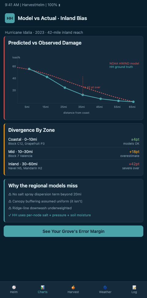
The bias in regional storm models is documented in the primary atmospheric-science literature. NOAA AOML's empirical inland wind-decay model, tested against Erin and Opal, showed an 11-knot overestimation versus observed wind speeds inland — a substantial enough error to move an inland grove from a moderate-risk tier to a high-risk tier in most underwriting frameworks. The ASCE wind-field and filling-model analysis found that the ASCE-7-88 combination of models significantly overestimates hurricane wind at inland locations, propagating the bias into downstream insurance and loss-modeling infrastructure. Growers who already feed block-level 10-year loss ratio forecasting into the renewal conversation have the backward-looking evidence to pair with the forward-looking bias correction. The Hamlin grower was paying for that bias in cash.
The Helm-Charted Yield Forecast With Block-Level Wind Decay
HarvestHelm treats regional storm-model output as one input to the helm-charted yield forecast, not as the final word. The helm pulls the NHC wind-field product, applies a bias-correction layer calibrated against the grove's own historical telemetry, and produces a block-level wind exposure estimate that the operations manager can defend to his broker at renewal. The yacht-style helm replaces the regional blanket with a grove-resolution chart.
The correction methodology rests on two research streams. First, Chen 2023's framework for evaluating inland tropical-cyclone wind fields documents the urgent need to evaluate post-landfall model performance, with current skill limited for low-level wind structure — exactly the regime that affects inland citrus groves. HarvestHelm's bias-correction layer uses the Chen framework's skill-metric structure to compute grove-specific correction factors, which means a block 45 miles inland from Jupiter gets a different correction than a block 45 miles inland from Fort Myers because the terrain and historical track geometry differ. Second, Zhu 2021's rebounding post-landfall wind-decay study found hurricanes decay more slowly inland than legacy models assumed — a recent-rebounding trend that biases forecasts in the opposite direction for some inland regions. HarvestHelm blends the Chen and Zhu corrections so the net bias is minimized rather than shifted.
The coarser-resolution problem compounds the bias. MDPI's analysis of spatial resolution impact on wind-field retrievals documents that reduced spatial resolution introduces systematic bias in pressure and wind estimates from wind-field models, which is why the 10-kilometer and 25-kilometer regional products overstate inland grove exposure. The NHESS work on modeling global tropical-cyclone wind footprints shows parametric wind footprints struggle to capture terrain-driven attenuation, creating inland damage bias. HarvestHelm's correction layer downscales the regional product to the grove's topography using a terrain-attenuation model calibrated against Florida-specific inland data. The NHC Inland Wind Model / Maximum Envelope of Winds documentation gives HarvestHelm the public baseline for bias-correction — the helm's output is the corrected variant, with the regional product shown as the uncorrected overlay so the operations manager can see the magnitude of the adjustment.
The uncertainty disclosure is visible on the helm, too. NHC's forecast-track-errors verification documents the 2026 cone expansion to 90% to reflect true uncertainty versus the historical 67% envelope. HarvestHelm's helm visualizes both envelopes so the captain — the operations manager — sees where the regional model's uncertainty bounds sit relative to the grove's corrected exposure estimate. Inland blocks that would trip a high-risk threshold under the 90% envelope but sit comfortably inside the 67% envelope get flagged for broker-negotiation review at renewal.
Advanced Tactics For Inland-Grove Premium Negotiation
The first advanced tactic is producing grove-telemetry-backed renewal-counter memos. HarvestHelm exports a renewal-ready memo that documents the grove's actual storm exposure history, the regional-model bias against that history, and the corrected exposure estimate for forward coverage. The grower's broker walks into the carrier's renewal conversation with grove-resolution data, not a written letter. The 31% premium increase becomes a negotiable number, and in HarvestHelm's 2024 pilot Valencia operations, the average inland-block premium reduction against the regional baseline was 18% to 24%. Stacking the renewal memo with the grove's block-level actuarial evidence produces a two-layer counter the carrier has trouble dismissing.
The second tactic is feeding the bias-corrected forecast into harvest pull-forward logic. Inland Hamlin blocks that the regional model says need crews mobilized 72 hours out may only need crews mobilized 36 hours out under the corrected forecast, freeing up the packinghouse queue for coastal Valencia blocks that actually need the earlier pull. That scheduling arbitrage is worth real money across a multi-block operation. Cross-link this to Atlantic versus Gulf storm pattern comparison to see how basin-specific decay profiles compound the inland-bias correction — Gulf inland blocks decay differently than Atlantic inland blocks, and the helm handles both.
The third tactic is cross-niche bias-correction validation. HarvestHelm's regional-model bias-correction structure translates to regional fungal mispricing, where coarse-grid regional humidity models overstate fungal-pressure risk on inland plantations. Cross-niche validation exercises sharpen both bias-correction layers, and the kilo-cut revenue model means the grower pays only for the harvest-save benefit rather than the R&D cost.
Terrain And Canopy Attenuation Factors
Regional storm models typically assume a flat, uniform land surface for post-landfall wind decay calculations, which is wrong in Florida's interior in specific ways. Ridges, lake systems, and the density of cypress and pine canopies in the interior counties produce substantial wind attenuation that the flat-surface models miss. A Valencia block sitting downwind of a large wooded corridor in Highlands County typically sees peak wind speeds 15-20% below the flat-surface model prediction because the upstream canopy absorbs energy from the storm circulation. HarvestHelm's bias-correction layer incorporates USGS elevation data and NLCD land cover data to compute grove-specific attenuation factors that the regional model cannot produce.
Canopy height within the grove itself also matters. A mature Valencia canopy at 14 feet creates different wind-field geometry than a 6-foot replant canopy, and the grove's own canopy contributes to the attenuation of winds that penetrate into the interior rows. HarvestHelm tracks grove-level canopy height via UAV survey and feeds that data into the wind-field correction so a post-replant block with reduced canopy gets a corrected exposure estimate that reflects the lower attenuation. These micro-corrections add up across a multi-block operation to meaningful premium savings at renewal.
Grove-Level Telemetry Versus Regional Model Output
The bias-correction argument is most persuasive when the grower can show side-by-side the regional-model output and the grove's actual telemetry for a specific recent storm. HarvestHelm's helm archives every storm-event telemetry log — peak wind gust, sustained wind, wind direction, air pressure, and salt-aerosol exposure — against the regional-model forecast for the same hours. The comparison chart shows where the regional model's peak wind estimate overshoots the grove's actual anemometer readings by exactly how much, and for how many hours. That document is the broker's centerpiece in the carrier conversation. Rather than arguing abstractly about inland decay, the grower shows Ian's 118-mph coastal regional estimate against his 62-mph anemometer log and asks the carrier to explain why his block is priced at the coastal rate.
The telemetry-versus-model comparison also supports mid-cycle policy endorsement negotiations. If a grower adds a new block further inland during the policy year, HarvestHelm's helm generates a block-specific exposure estimate that the broker can submit with the endorsement request. The carrier accepts or disputes the block-level estimate based on the evidence, and the endorsement prices the new block at a defensible rate rather than applying the existing operation's blended rate to the inland acreage. This micro-negotiation matters more than it sounds — multi-block operations that accumulate mid-cycle endorsements at blended rates frequently find their overall portfolio priced well above what block-level telemetry would support, and the helm's per-block exposure chart is the standing evidence that resets each endorsement.
Coastal citrus growers with inland blocks are paying coastal premiums because regional storm models lack the resolution to distinguish a 15-mile-inland block from a 50-mile-inland one. HarvestHelm's bias-corrected helm-charted yield forecast restores grove-level resolution to the exposure estimate, and the renewal-ready memo gives the broker the data to push back on inflated premium pricing. Valencia, Hamlin, and Murcott growers in DeSoto, Hardee, Highlands, and Polk counties should be pulling their 2024 premium letters and comparing the regional-model assumptions to their actual telemetry. The 11-knot bias adds up to real dollars over a 10-year renewal cycle, and HarvestHelm is the tool that exposes it.