Stitching Dust Plume Satellite Feeds Into Oasis-Level Alerts
The Resolution Gap Between Global Forecasts and Your Row
Date palm cultivators live inside a scale mismatch. The WMO Sand and Dust Storm Warning Advisory and Assessment System coordinates a global network of 9 global and 15+ regional dust models, publishing daily forecasts for haboobs, khamsin events, and frontal dust surges. ECMWF CAMS operates operational dust AOD forecasts assimilating MODIS and VIIRS satellite data. NASA's MODIS imagery captures Middle East dust plume extent and trajectory in near-real-time.
All of these products are excellent at what they're designed for: continental-to-regional dust surveillance. None of them are designed to answer the question a Tozeur, Biskra, or Coachella Valley grower actually asks: is my specific 200-palm block going to be in the plume at 14:00, or will it pass 8 kilometers to the north? The resolution gap is structural. A 0.25° grid cell at 32°N latitude spans roughly 25 km east-west; a 0.75° cell spans about 75 km. A palm grove is rarely more than a kilometer across. Between the satellite forecast and the palm, there are 25 to 5,625 square kilometers of ground the forecast does not resolve.
The World Bank's MENA dust storm report quantifies MENA dust storm crop damage at hundreds of millions of dollars per event. A meaningful fraction of that damage occurs on the wrong side of the resolution gap: growers who saw the regional forecast, couldn't resolve it to their parcel, and either treated it as a false alarm and got hit, or treated every alert as real and burned their crews on evacuations that weren't needed. Both failure modes are expensive.
The Helm-Charted Yield Forecast With Satellite Fusion
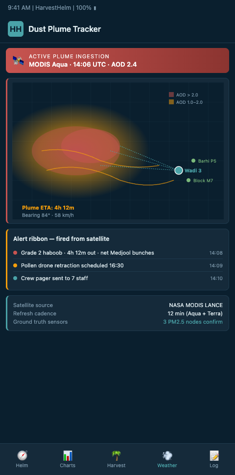
HarvestHelm stitches satellite dust feeds into parcel-level alerts by treating the problem as a sensor fusion problem — the yacht dashboard needs a single confidence-weighted reading, not seven raw feeds. Our helm-charted yield forecast ingests dust forecast fields from multiple sources, applies trajectory refinement using local surface wind measurements, and delivers an arrival-window prediction for each specific parcel with explicit uncertainty bounds.
The fusion pipeline runs in four stages. First, we ingest global dust AOD fields from CAMS and regional WMO SDS-WAS nodes at their native resolution. The investigation of dust trends in NASA GEOS model simulations shows AOD trend increases of 0.01-0.04/year in MENA — meaning the forecast fields are not only a snapshot but a moving baseline we have to calibrate against. Our pipeline tracks that drift so that an alert threshold from 2020 automatically adjusts for 2026 baseline conditions.
Second, we downscale. We use local surface wind measurements from the same oasis sensor mesh that powers our diurnal telemetry to refine plume trajectory as it approaches parcel-scale resolution. The PMC study on monitoring dust storms in Iraq using MODIS surface reflectance and NDDI documents methodology transferable to oasis-level mapping. We apply similar index-based techniques to recent satellite passes combined with the grower's own hyperlocal wind field, producing a parcel-level arrival estimate with 15-40 minute resolution rather than multi-hour blocks. This ties directly to the mesh architecture we describe in our post on wadi sensor scaling — the parcel-level fusion only works if enough ground-truth nodes exist to anchor the downscaling.
Third, we cross-validate. No single satellite product catches every dust event, and some products miss fast-moving haboobs entirely. The WMO partnership enhancing sand and dust storm early warnings builds multi-agency fusion as the backbone of modern dust forecasting. We apply the same principle at the individual-grove level: an alert fires only when at least two independent satellite-product streams corroborate, and we weight the alert confidence by the agreement level. A unanimous alert across CAMS, SDS-WAS, and a regional node fires at confidence 92%; a single-source alert fires at 45% and is surfaced as a watch rather than a warning.
Fourth, the yacht dashboard integrates the dust alert into the overall parcel forecast. The helm does not show a grower eight disparate feeds to reconcile — it shows one plume trajectory with an arrival window, a confidence envelope, and a parcel-specific impact estimate. A 720-palm Medjool block expecting a 14:15 haboob arrival at 78% confidence gets a pollination deadline shown at 13:00 and a crew-evacuation call shown at 13:45, both pinned to the single fused forecast. This workflow feeds directly into the haboob dashboard workflow we describe in our post on haboob dashboard workflow, where parcel-level fusion drives the warning-window clocks that crews actually steer by.
Advanced Tactics for Satellite-to-Parcel Fusion
The first advanced move is source-weighting by event type. Different satellite products excel at different dust regimes. Large regional dust blooms are well-captured by MODIS true-color imagery; fast-moving haboobs are better detected by VIIRS brightness-temperature differences; khamsin events with elevated RH require CAMS aerosol composition data. We assign per-product trust weights conditioned on the meteorological regime of the forecast day. A spring khamsin trigger conditions differently on AOD alone than a summer haboob trigger does, and the helm encodes that.
The second tactic is temporal stacking. A single satellite pass tells you where dust is now; two passes separated by 3 hours tell you velocity and acceleration. Our pipeline maintains a rolling 24-hour stack of dust-field images and computes optical-flow trajectories that project plume motion forward by 6-18 hours. This extends the lead time beyond what any single forecast product offers by chaining observations through a kinematic model — the yacht dashboard's analogy is continuous radar tracking rather than discrete position fixes. The 24-hour stack is what gives growers the 9-hour lead time that makes compressed pre-storm pollination rescues operationally feasible.
The third tactic is cross-niche parallel processing. Satellite-fused alerts are not unique to dust storms — the same architecture applies to tropical cyclone trajectories for coastal citrus and monsoon-front tracking for tropical mango. Our engineering team maintains a shared fusion core that powers doppler radar alerts for mango plantations against similar resolution gaps. The cross-niche consistency means our satellite fusion stack gets better across all crops when we improve any one of them — a haboob detection upgrade from a MENA oasis deployment improves hurricane detection logic in Florida citrus groves.
The fourth tactic is alert latency discipline. A fused alert that arrives 18 minutes after the first ground-truth sensor detected dust is operationally useless — the grower's own eyes beat it. Our pipeline enforces a strict 3-5 minute end-to-end latency budget from satellite pass ingestion to dashboard alert delivery, verified against a continuous integration test suite that simulates real dust events against the production system. Latency drift is a silent killer in agritech — the system that worked last spring may have accumulated 45 seconds of slack since then, and that slack matters when a crew needs to evacuate.
The fifth tactic is false-alarm management through post-event calibration. Every fired alert is evaluated after the fact against whether actual dust impact occurred — wind speeds exceeded threshold, AOD readings spiked, visibility degraded. Alerts that fired but did not materialize get tagged as false alarms and feed back into the confidence-weighting of the source combination that produced them. Over time, the ensemble weights self-calibrate toward sources that have proven reliable for the specific oasis's regime. A Coachella Valley deployment learns which CAMS model configurations catch Sonoran-basin dust events; a Kebili deployment learns which WMO regional node catches Saharan dust surges. The cross-calibration is automated and transparent on the dashboard — growers can see the false-alarm rate of their current alert configuration.
The sixth tactic is pre-event scenario drill integration. On weather days where a storm is approaching but not yet imminent — say 36-48 hours out — the helm runs a "rehearsal" scenario, walking the grower through what the alert sequence would look like if the storm maintains its current track. This rehearsal shows the ladder-crew dispatch changes, pollination-rescue pollen draws, and evacuation timing that would kick in. The rehearsal is non-binding; it's planning visibility. Growers who rehearse with the yacht dashboard once or twice a season execute real alerts more confidently than growers seeing the sequence for the first time mid-haboob.
The seventh tactic is multi-oasis pattern learning. With parallel deployments across multiple oases, the pipeline learns patterns that single-site deployments miss. When a khamsin front moves through Tozeur six hours before reaching Kebili, the Kebili deployment can use the Tozeur impact data as forward-looking ground truth — effectively extending Kebili's lead time by six hours. This cross-oasis learning compounds as the deployment base grows, and every new oasis participating in the fusion network improves the alert quality for all existing participants. That network-effect dynamic is specifically what makes a multi-parcel multi-oasis architecture more powerful than any single-site deployment could be.
Alert the Parcel, Not the Province
If you've ever stared at a provincial dust advisory wondering whether it applies to your specific Medjool, Deglet Noor, or Barhi block, HarvestHelm closes the resolution gap that makes those advisories operationally ambiguous. We fuse CAMS, SDS-WAS, MODIS, and VIIRS feeds with your oasis's own wind-field telemetry to produce a parcel-level arrival window with explicit confidence bounds — so your crew evacuation call is triggered by a corroborated 78% alert, not a province-wide hedge. Because our kilo-cut pricing takes only a share of the successful harvest, we pay the engineering cost of running multi-source fusion ourselves and pass the alert reliability to you as part of the product.
If you want to see how satellite fusion would resolve over your specific parcels during a historical khamsin event, we'll run a retrospective playback on your oasis and show you which alerts would have fired when — no contract required. Join the satellite-fusion waitlist before your next Medjool pollination window opens this March, and on day one you will see parcel-level arrival cones with 80th-percentile confidence bands layered over your wadi geometry. Waitlisted Biskra and Tozeur cooperatives who completed retrospective playback ahead of last khamsin season validated which of their Zahidi and Barhi blocks had been sitting exposed to undetected plumes across three prior events.